


Good Morning! Today is Monday, September 14, 2026. Here is today’s forecast:
There were scattered showers and thunderstorms around Sunday evening and overnight as a cold front worked its way through the state. Today, there are going to be scattered showers and isolated thunderstorms around in central and north-central Montana as an upper-level low continues to track through the region. In northeastern Montana, rain showers are likely today and some of the rain that falls may be heavy at times. There will also be a little snow in some of the mountains today, with snow levels as low as 6500 feet. Skies today will be partly to mostly cloudy.
In northeastern Montana, .25” to .75” of rain is expected in a lot of locations today, with a few areas possibly receiving up to or over 1”. In north-central and central Montana, less than .15” of rain is expected in most locations today. In the mountains, a coating to a couple inches of accumulation is possible.


Widespread gusty to strong winds are also expected today, with the strongest winds along the Rocky Mountain Front and east of I-15. In these areas, sustained winds of 15 to 35 mph and gusts of 40 to 60 mph are likely. Elsewhere, sustained winds will range from 10 to 30 mph, with gusts of 30 to 50 mph.
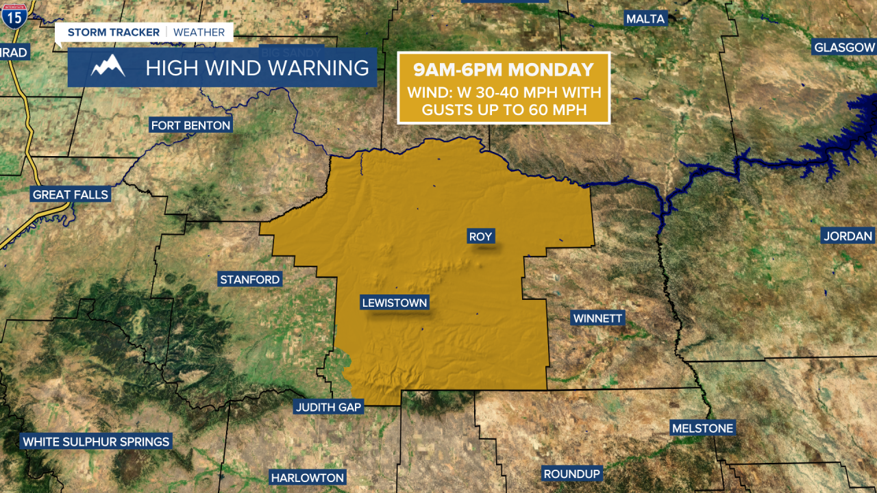
A HIGH WIND WARNING is in effect for Fergus County from 9am until 6pm today and a LAKE WIND ADVISORY is in effect for Fort Peck Lake until midnight tonight. The wind will gradually diminish from west to east as we go through this evening and early tonight.

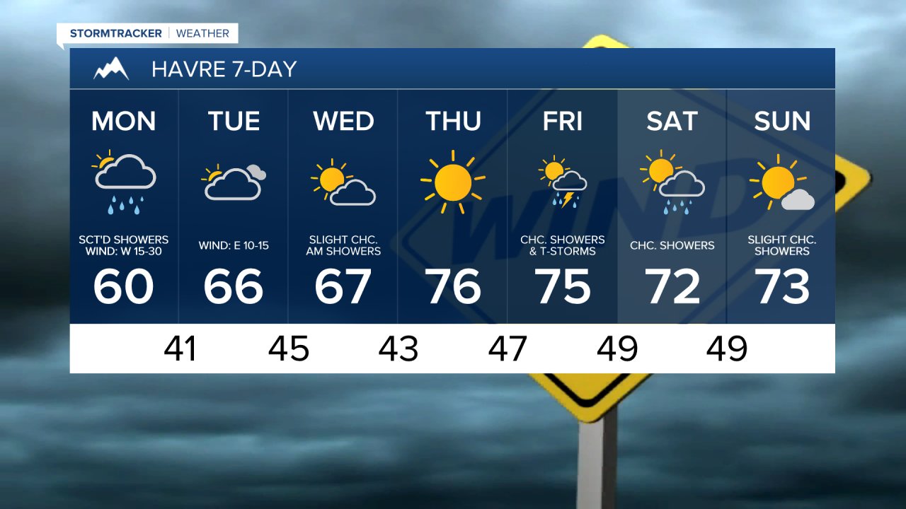
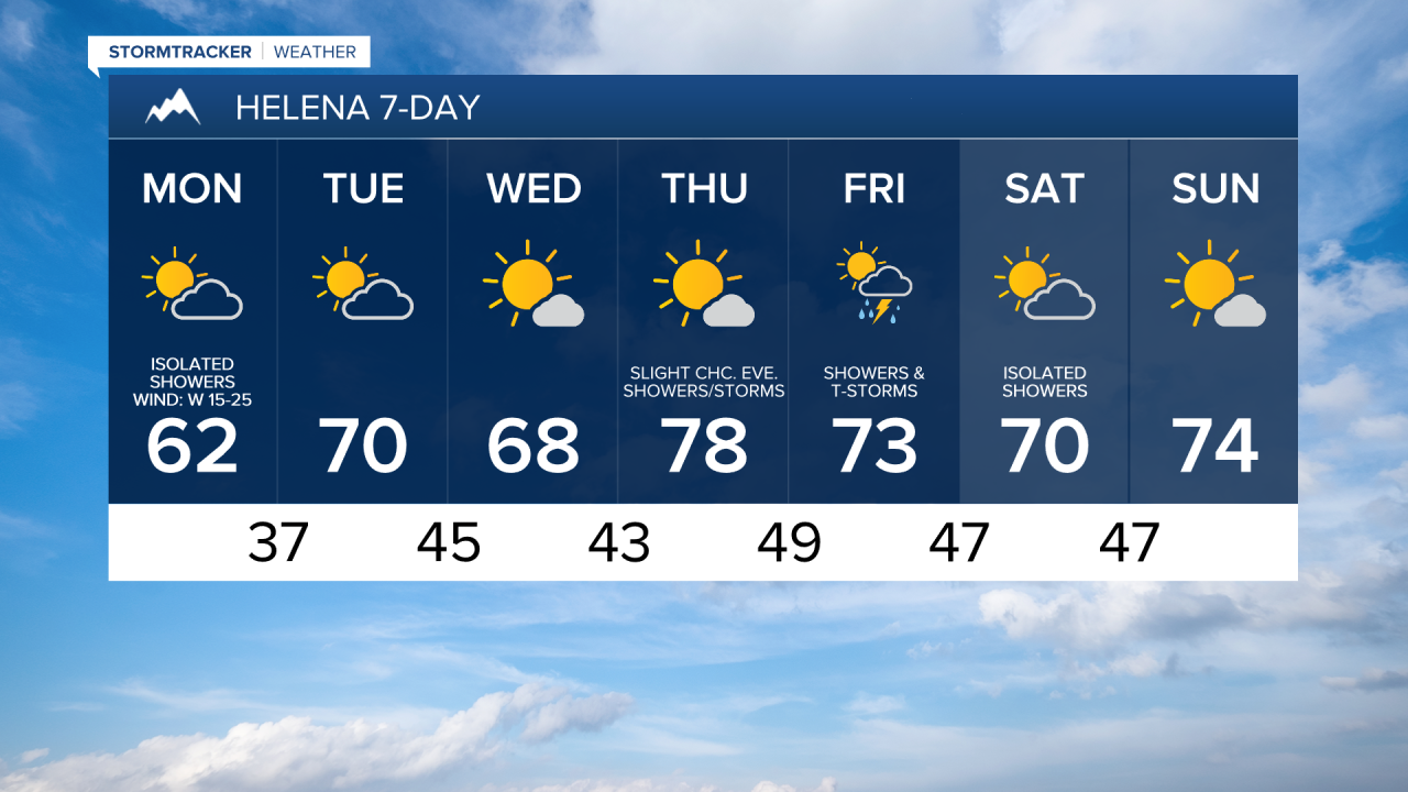
Today will also be the coolest day of the week, with high temperatures only in the 50s and low 60s.
Tomorrow will be partly to mostly cloudy and mostly dry. Winds will be noticeably lighter, with sustained speeds of 5 to 20 mph, and temperatures will rebound into the 60s and low 70s.
A few showers are possible tomorrow night and Wednesday morning, generally along the Hi-Line and the Rocky Mountain Front, as a disturbance passes through our area. On Wednesday, it is going to be partly to mostly sunny, with the skies clearing out as the day goes on. Highs on Wednesday will be in the 60s and it will be a little breezy in some areas with sustained winds of 5-20 mph.
Picture perfect weather is expected on Thursday as an upper-level ridge will be in control of our weather. Expect abundant sunshine, mostly dry conditions, light winds, and pleasant temperatures, with highs in the 70s.
There will be scattered showers and thunderstorms around on Friday, especially in central Montana, as another disturbance passes through our area. Skies will be partly cloudy. On Saturday, it is going to be partly to mostly sunny and there will be some scattered showers around, generally in the mountains and in locations east of I-15, as this disturbance departs our area.
Temperatures will remain comfortable Friday and Saturday, with highs in the mid to upper 60s and low to mid 70s. Winds will be light.
On Sunday, it is going to be partly to mostly sunny and mostly dry, just a few isolated showers around. Highs on Sunday will be in the upper 60s and low to mid 70s.


Have a magnificent Monday!
Chief Meteorologist Ryan Dennis
