A HIGH WIND WATCH is in effect for Glacier County, northern Lewis and Clark County, Liberty County, western/central Pondera County, western/central Teton County, and Toole County from 9pm Wednesday until 3pm Thursday.

A LAKE WIND ADVISORY is in effect for Fort Peck Lake from 6am until 8pm Thursday.

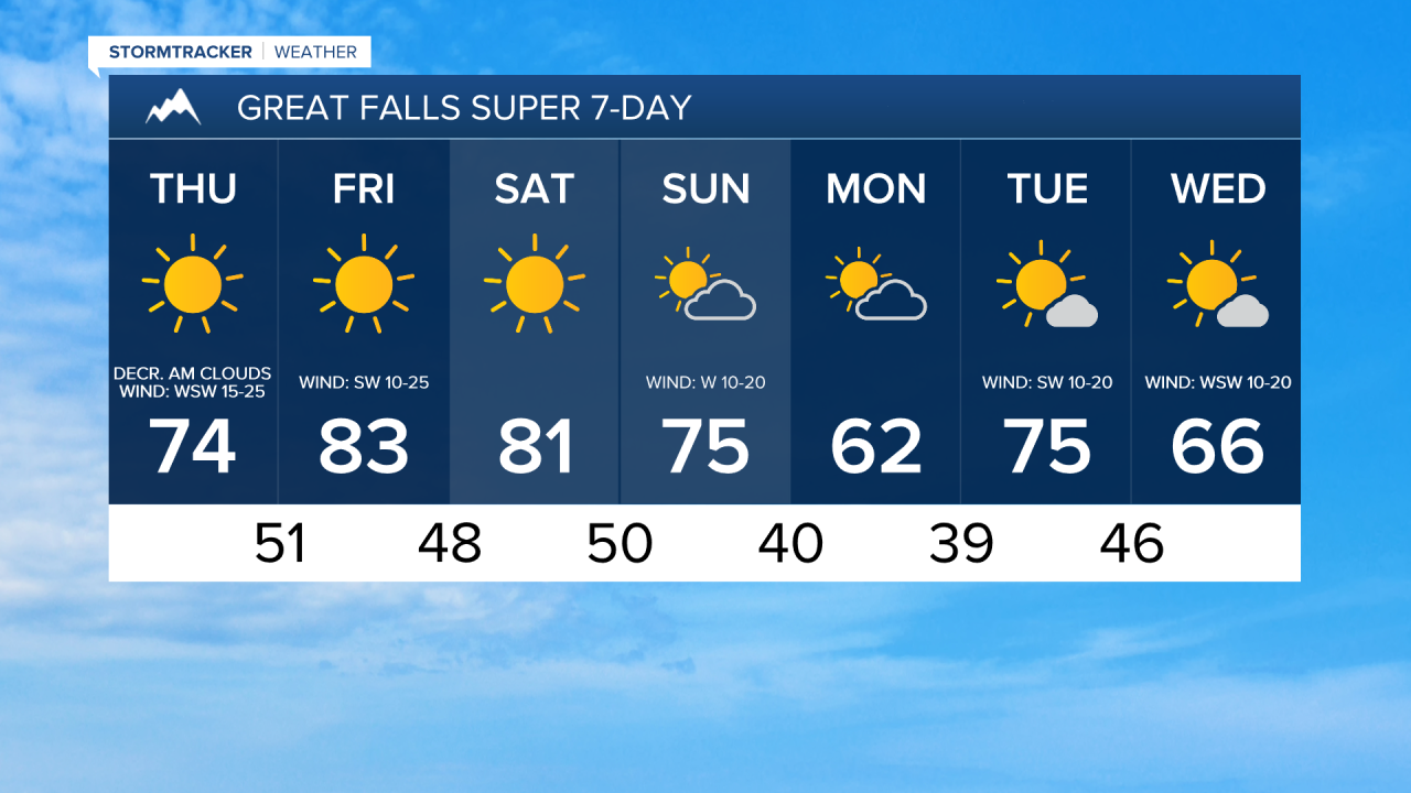
There are going to be a few showers and isolated thunderstorms around tonight and tomorrow morning, mainly in the Rockies and along the Rocky Mountain Front, as a cold front passes through our area. East of the Rocky Mountain Front, most locations will remain dry, although an isolated shower is possible. We are also going to have increasing clouds later on tonight and decreasing clouds tomorrow morning, resulting in lots of sunshine for tomorrow afternoon and evening.
The wind is also going to increase as we go through tonight, with widespread windy conditions expected tomorrow, especially during the morning and the early afternoon. As we go through tomorrow afternoon and evening, the wind is going to gradually diminish from west to east. Along the Rocky Mountain Front and the western half of the Hi-Line, sustained wind speeds later tonight and tomorrow are going to be between 20 and 40 mph, and wind gusts up to 60 mph are possible. Elsewhere, sustained wind speeds later tonight and tomorrow are going to be between 10 and 30 mph, and wind gusts over 40 mph are possible at times.
It is also going to be mild tonight as lows are going to be in the 50s in a lot of locations. It is then going to be cooler tomorrow than it was today as highs are going to be in the 70s and mid to upper 60s in most locations.
Mainly sunny skies and dry conditions are then expected on Friday and Saturday as an upper-level ridge is going to be in control of our weather. We are also going to continue to have above average temperatures on these two days as highs are going to be in the mid to upper 70s and low to mid 80s in most locations. It is also going to be windy again on Friday along the Rocky Mountain Front as sustained wind speeds are going to be between 15 and 30 mph, and it is going to be breezy in some areas east of the Rocky Mountain Front on Friday as sustained wind speeds are going to be between 10 and 25 mph.
We are then going to have partly to mostly sunny skies on Sunday and Monday with a couple isolated showers around as another disturbance passes through our area. The temperatures are also going to cool down some between these two days as highs are going to be in the 70s and 80s on Sunday and highs are going to be in the mid to upper 50s and low to mid 60s on Monday. There is also going to be a bit of a breeze around on these two days as sustained wind speeds are going to be between 10 and 20 mph.
Partly to mostly sunny skies and mainly dry conditions are then expected on Tuesday and Wednesday. It is also going to be warmer on Tuesday than it is going to be on Monday as highs are going to be in the 70s, but the temperatures will cool back down into the 60s for Wednesday. There is also going to be a breeze around on these two days as sustained wind speeds are going to be between 10 and 20 mph.