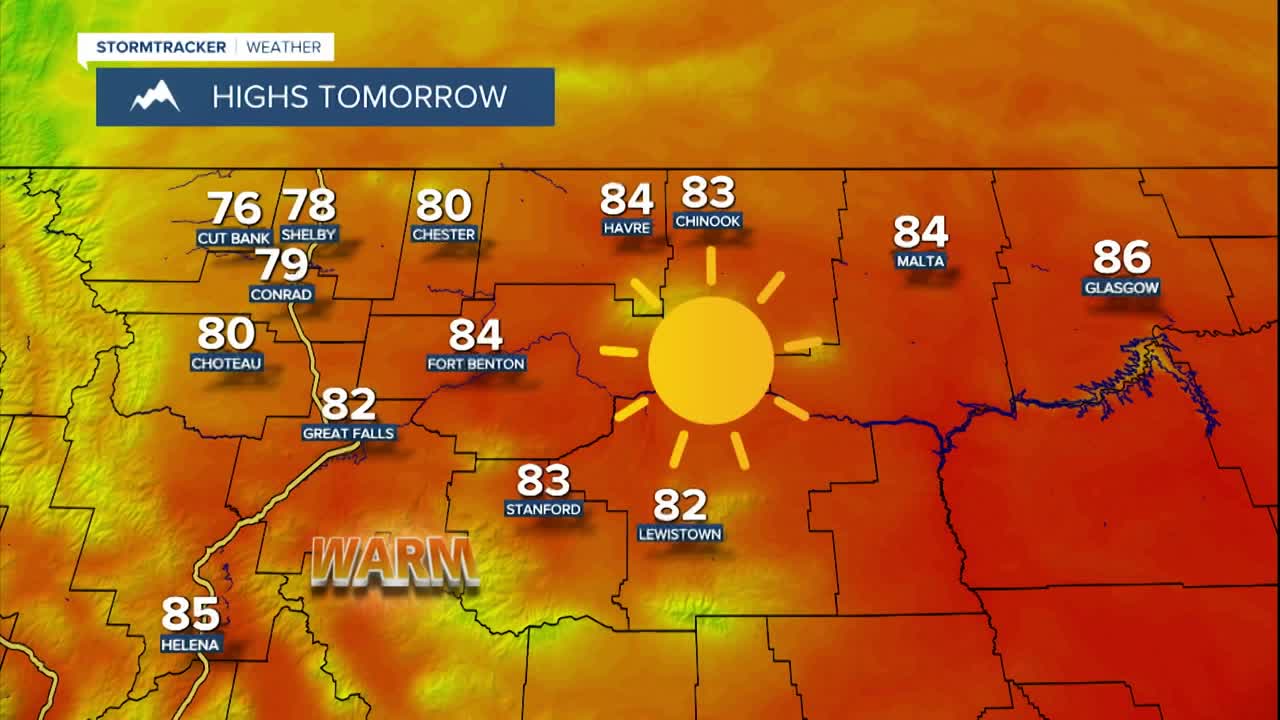


We are going to have partly cloudy to mostly clear skies between I-15 and the Rockies in north-central Montana tonight. Everywhere else, we are going to have mainly clear skies tonight. It is also going to be cool tonight as lows are going to be in the 40s in most locations. We are then going to have beautiful summer-like weather tomorrow as we are going to have lots of sunshine, dry conditions, little wind (sustained wind speeds between 5 and 15 mph), and warm temperatures as highs are going to be in the mid to upper 70s and low to mid 80s.
On Sunday, we are going to have partly to mostly sunny skies with a slim chance of showers as a cold front begins to pass through our area. We are also going to have increasing wind from west to east as we go through the day. Along the Rocky Mountain Front, it will be windy for most of Sunday as sustained wind speeds are going to be between 20 and 40 mph, and wind gusts up to 60 mph are possible. Elsewhere, it is going to become windy as the day goes on as sustained wind speeds Sunday afternoon/evening and Sunday night are going to be between 10 and 30 mph, and wind gusts over 40 mph are likely. As we go through Sunday night, this wind is going to gradually diminish from west to east. It is also going to continue to be warm on Sunday as highs are going to be in the 70s and 80s, with the warmest temperatures in northeastern Montana.
On Monday, we are going to have partly to mostly sunny skies and mainly dry conditions as Sunday’s cold front leaves our area. It is also going to be a lot cooler on Monday than it is going to be this weekend as highs are going to be in the mid to upper 50s and low to mid 60s in most locations. There is also going to continue to be a breeze around in some areas on Monday as sustained wind speeds are going to be between 10 and 20 mph.
We are then going to have partly to mostly sunny skies and mainly dry conditions for the rest of next week (Tuesday through Friday) as an upper-level ridge is going to be in control of our weather, although there are going to be a few disturbances that are going to pass by our area to the north. It is also going to be warmer on Tuesday than it is going to be on Monday as highs are going to be in the mid to upper 60s and low to mid 70s in most locations. We are then going to have near to slightly above average temperatures Wednesday through Friday as highs are going to be in the 60s and low 70s in most locations.
Gusty winds are also expected on Tuesday as sustained wind speeds are going to be between 10 and 30 mph, and wind gusts over 40 mph are possible. It is then going to be breezy on Wednesday as sustained wind speeds are going to be between 10 and 25 mph, and it is going to be a little breezy on Thursday and Friday as sustained wind speeds are going to be between 5 and 20 mph.


