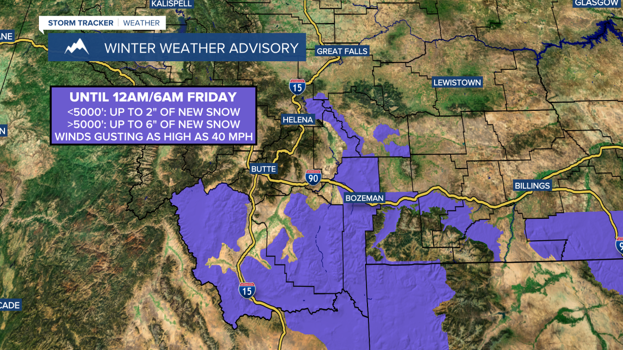
A WINTER WEATHER ADVISORY is in effect for portions of southwestern Montana (including the Big Belt Mountains) until 12am/6am Friday.
The total lunar eclipse is tonight! A total lunar eclipse occurs when the Moon is full and when the Sun, Earth, and Moon are all in a straight line, with the Earth casting a shadow on the Moon. The longer wavelength colors (red and orange) from the Sun pass through Earth’s atmosphere and then get refracted onto the Moon’s surface, making it appear red/orange. Totality will occur between 12:26am MDT and 1:31am MDT, this is when the moon will be completely red.
Sadly, viewing conditions won't be that great as mostly cloudy skies are expected throughout a lot of Montana tonight, but there should be a few breaks in the clouds in central Montana allowing some of us to at least get a glimpse of the red moon. The best viewing conditions tonight will be in the western part of the state.
Gusty winds will diminish in western portions of north-central Montana as we go through this evening and tonight. In eastern portions of north-central Montana and along the Rocky Mountain Front, it will be breezy this evening and tonight as sustained wind speeds are going to be between 10 and 20 mph. There are also going to be a few scattered rain and mountain snow showers around this evening and tonight, mainly in central Montana and in eastern portions of north-central Montana. A little snow and sleet may also mix in with this rain at times in the lower elevations. It is also going to be a bit chilly tonight as lows are going to be in the 20s and low 30s.
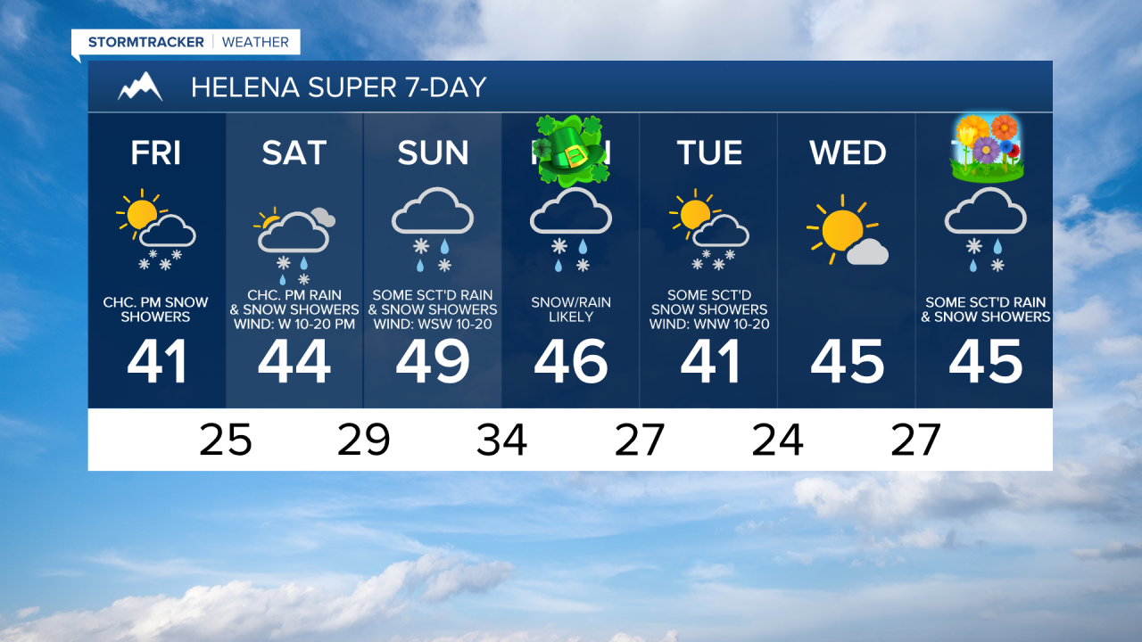
For tomorrow, we are going to have partly cloudy skies with some scattered rain and snow showers around during the afternoon and evening, especially in the mountains. Showers will be brief and won’t amount to much. It is also going to be a lot cooler tomorrow than it was today as highs are going to be in the mid to upper 30s and low to mid 40s. There is also going to be a bit of a breeze around in some areas tomorrow as sustained wind speeds are going to be between 10 and 20 mph.
We are then going to have partly to mostly cloudy skies on Saturday with some scattered rain and snow showers around during the afternoon and evening as a disturbance begins to pass through our area. There are then going to be some more scattered rain and snow showers around on Sunday, especially around Helena, in the mountains, and in locations east of I-15 in north-central Montana, as Saturday’s disturbance leaves our area and as another disturbance begins to impact our area. Although there will be some scattered showers around this weekend, not everyone will see this precipitation and more of the weekend will be dry than “wet”. We are also going to have mostly cloudy skies on Sunday.
It is also going to be breezy on Saturday along the Rocky Mountain Front and in/around Cascade County as sustained wind speeds are going to be between 10 and 20 mph. Gusty winds are then expected on Sunday as sustained wind speeds are going to be between 10 and 30 mph, and wind gusts over 40 mph are possible. Per usual, even stronger wind is expected along the Rocky Mountain Front, where gusts over 50 mph will be possible on Sunday. It is also going to be cool on Saturday as highs are going to be in the 40s and mid to upper 30s. It will then be a little bit warmer on Sunday as highs are going to be in the mid to upper 40s and low 50s.
Snow/rain is then likely around Helena on St. Patrick’s Day (Monday), and there are going to be some scattered snow/rain showers around in north-central Montana on Monday as another disturbance passes through our area. There are then going to be some more scattered snow showers around on Tuesday. We are also going to have mostly cloudy skies on Monday and partly cloudy skies on Tuesday. We are then going to have mostly sunny skies and dry conditions on Wednesday.
There is also going to be a good breeze around on Monday as sustained wind speeds are going to be between 10 and 25 mph, and wind gusts up to 40 mph are possible. It is then going to be a bit breezy on Tuesday and Wednesday as sustained wind speeds are going to be between 10 and 20 mph. We are also going to have seasonable temperatures on these three days as highs are going to be in the upper 30s, 40s, and low 50s, with Tuesday being the coolest day.
Next Thursday is the first day of Spring! Spring officially begins at 3:01am MDT on Thursday. To begin Spring, we will have seasonable temperatures (highs in the mid to upper 40s and low to mid 50s), breezy conditions (sustained wind speeds between 10 and 25 mph), and mostly cloudy skies with a chance of rain and snow showers, generally around Helena.