


A COLD WEATHER ADVISORY is in effect for a lot of the Hi-Line until 10am/12pm Saturday.

A WINTER WEATHER ADVISORY is in effect for portions of central and western Montana until Saturday morning.

A WINTER STORM WATCH is in effect for portions of central Montana from Sunday morning until 5pm Monday/11am Tuesday.

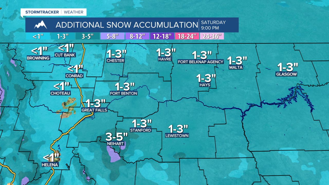
There are going to be areas of light to moderate snow around this evening and tonight, especially before midnight, as a disturbance continues to work its way through Montana. In the lower elevations, up to 3” of new snow is possible, and in the mountains, up to 5” of new snow is possible. It is also going to be cold tonight as lows are going to be in the -0s and 0s, and there is going to be a little breeze around in some areas tonight as sustained wind speeds are going to be between 5 and 15 mph. Wind chills as low as -30° are also possible tonight along the Hi-Line.
For tomorrow, we are going to have mostly cloudy skies with some scattered light/very fine snow around during the morning and evening. Little (a coating) to no snow accumulation is expected. It is also going to be cold again tomorrow in north-central Montana as highs are going to be in the 0s. Around Helena, it is going to be chilly tomorrow as highs are going to be in the upper teens and low to mid 20s. There is also going to be a breeze around tomorrow along the Divide and in the mountains in central Montana as sustained wind speeds are going to be between 10 and 25 mph, and this wind will cause there to be areas of blowing snow.
There is then going to be scattered snow around tomorrow night, with the snow becoming more widespread in central Montana and western portions of north-central Montana during the second half of the night. Snow is then likely on Sunday and Monday in locations west of a line from Havre to Miles City. This means it will be very snowy on these two days around Cut Bank, Great Falls, Helena and Lewistown. Some of the snow that falls over these two days will be heavy at times. Around and east of a line from Havre to Miles City, it will be partly to mostly cloudy with a small chance of snow on these two days. As we go through Monday night and Tuesday, this snow will taper off from north to south and the skies will clear out from north to south.
Significant snow accumulations are expected in central Montana and western portions of north-central Montana, including around Cut Bank, Great Falls, Havre, and Lewistown, from tomorrow night through Tuesday. In these areas, 4-10” of snow is expected in the lower elevations, and 6-14+” of snow is expected in the mountains and along the Rocky Mountain Front. The further north and east of Great Falls you go, the lower the snow amounts will be, with little to no snow accumulation expected from Havre to Glasgow. There is going to be a sharp cutoff in north-central Montana between nothing and several inches of snow, and any change in the storm’s path will change where this cutoff line will be, so stay tuned to KRTV/KXLH for the latest updates.

Sunday is going to be another very cold day as highs are only going to be in the -0s and 0s in north-central Montana and the upper 0s, 10s, and low 20s around Helena. Another reinforcing shot of arctic air is then expected for Sunday night through Wednesday as lows at night are going to be in the -0s, -10s, and -20s in most locations, and highs on Monday and Tuesday are going to be in the -10s and -0s in north-central Montana and the 0s and 10s around Helena. On Wednesday, it will be a little warmer as highs are going to be in the -0s and 0s in north-central Montana and the 10s in central Montana.
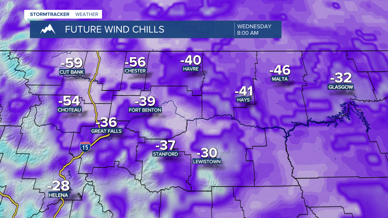
The coldest temperatures early next week are going to be along the Hi-Line. This is where a few spots may drop down into the -30s at night. Dangerously cold wind chills are also expected early next week, with wind chills in the -30s, -40s, and -50s along the Hi-Line, and the -10s, -20s, and -30s in locations south of the Hi-Line. Make sure you limit your time outdoors early next week, and if you do have to be outside, make sure you wear multiple layers and cover all exposed skin.
On Wednesday, we are going to have partly to mostly sunny skies and mainly dry conditions. We are then going to have partly cloudy skies with a few isolated snow showers around on Thursday and Friday, generally in the mountains. Our long-awaited warm-up finally arrives later next week as highs are going to be in the 10s, 20s, and low to mid 30s on Thursday (coldest temps along the Hi-Line east of I-15) and the 30s and low 40s on Friday. The wind will also pick back up later next week as widespread breezy conditions are expected on Friday as sustained wind speeds are going to be between 10 and 25 mph.
Above average temperatures are then expected next weekend and for the final week of February as highs are going to be in the 40s, and a few spots may even get into the 50s! So yes, it will be brutally cold early next week, but spring-like warmth will be here soon! 😊


