

An AIR QUALITY ALERT is in effect for portions of central and eastern Montana until at least 9am Tuesday. The air quality is going to be unhealthy for sensitive groups at times.

A LAKE WIND ADVISORY is in effect for Fort Peck Lake until 9pm Tuesday. Sustained wind speeds are going to be between 15 and 25 mph, and wind gusts up to 35 mph are going to be possible at times.

Showers and thunderstorms associated with a cold front will work there way out of Montana this evening, and most of the state will have mainly clear skies and mainly dry conditions tonight. It is also going to be hazy tonight in eastern Montana and just a little hazy elsewhere. Gusty winds will continue this evening, but they will weaken a little bit as we get closer to sunset. It is then going to be breezy in some areas tonight as sustained wind speeds are going to be between 10 and 20 mph, and wind gusts over 30 mph are going to be possible at times. It is also going to be cool tonight as lows are going to be in the 50s and upper 40s.
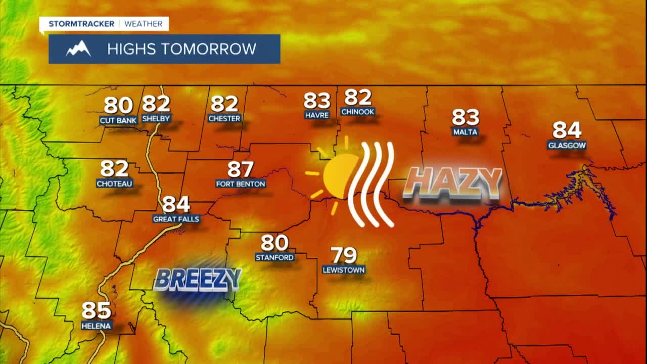
For tomorrow, we are going to have mainly sunny skies and dry conditions. The haze/smoke is also going to increase in northern Montana as we go through tomorrow as some wildfire smoke from Canada works its way back into our area, and this smoke may cause the air quality to become unhealthy for sensitive groups in some locations.

It is also going to be cooler tomorrow than it was today as highs are going to be in the upper 70s and low to mid 80s. There is also going to be a breeze around throughout the day tomorrow as sustained wind speeds are going to be between 10 and 25 mph, and wind gusts up to 40 mph are going to be possible at times. Also, this wind is going to be coming out of the west/northwest in most locations.
On Wednesday, we are going to have mainly sunny skies, dry conditions, and pleasant temperatures as highs are going to be in the upper 70s and low to mid 80s. It is also going to be hazy again on Wednesday, and the haze will increase some as the day goes on.
For Thursday and Friday, we are going to have mostly to mainly sunny skies with a slight chance of PM showers and thunderstorms. It may also continue to be hazy on these two days. The temperatures are also going to warm up some over these two days as highs are going to be in the mid to upper 80s and low 90s on Thursday, and the upper 80s and low to mid 90s on Friday. It is also going to be a little breezy on these two days as sustained wind speeds are going to be between 5 and 20 mph.
It is then going to be very hot this weekend and early next week (thanks to a strong upper-level ridge) as highs are going to be in the mid to upper 90s and low 100s. We are also going to have lots of sunshine and dry conditions on Saturday; partly cloudy to mostly sunny skies and mainly dry conditions on Sunday; and mostly sunny skies and dry conditions on Monday. It is also going to be a little breezy on these three days as sustained wind speeds are going to be between 5 and 20 mph.


