


A COLD WEATHER ADVISORY is in effect for portions of northeastern Montana from 9pm Thursday until 12pm Friday.

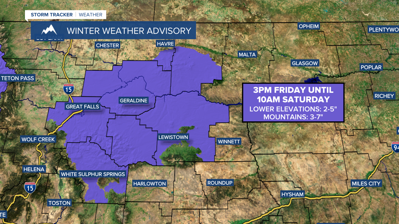
A WINTER WEATHER ADVISORY is in effect for portions of north-central Montana from 3pm Friday until 10am Saturday.
A WINTER STORM WATCH is in effect for portions of southwestern Montana from 3pm Friday until 10am Saturday.

There are going to be areas of light to moderate snow around from this evening through tomorrow night as a disturbance passes through our area, with the bulk of the accumulating snow occurring tomorrow afternoon through tomorrow night. In the lower elevations, 1-4” of snow is expected in most spots, with isolated locations receiving up to 5” of snow. In the mountains, 3-7” of snow is expected, with higher amounts possible in the Big Belt mountains east of Helena. This snow will cause the roads to become slick/snow-covered, so please use caution when driving.

It is going to be warmer tonight than it has been the past several nights, but it is still going to be really cold as lows are going to be in the -0s and 0s. It is then going to be really cold again tomorrow as highs are going to be in the single digits in most locations (some teens around Helena). It is also going to be a little breezy tonight and tomorrow in some areas (especially along the Hi-Line) as sustained wind speeds are going to be between 5 and 20 mph, and gusts over 30 mph are possible. This wind will cause there to be some blowing snow around, so please use caution when driving.
On Saturday, we are going to have mostly cloudy skies with a few snow showers around, especially during the morning and especially in the mountains. It is also going to be cold again on Saturday in north-central Montana as highs are going to be in the single digits. Around Helena, it is going to be warmer on Saturday than it is going to be tomorrow as highs are going to be in the teens and low to mid 20s. Breezy conditions are also expected on Saturday along the Divide and in the mountains in central Montana as sustained wind speeds are going to be between 10 and 25 mph.
There is then going to be widespread accumulating snow around on Sunday and Monday in central and north-central Montana as another storm system impacts our area. The heaviest snow with this storm will fall in central Montana and in western portions of north-central Montana (including around Cut Bank, Great Falls, Helena, and Lewistown), and this is where several inches of snow accumulation is possible over these two days. In northeastern Montana, there is going to be some scattered light snow around on these two days, and light snow accumulations are possible.
It is also going to continue to be very cold on these two days as highs are going to be in the -0s and 0s in north-central Montana and the 0s and 10s around Helena.
On Tuesday, we are going to have decreasing clouds with isolated snow showers around in north-central Montana, generally during the morning, and scattered snow around Helena, especially during the morning, as Sunday’s/Monday’s storm system leaves our area. It is also going to remain frigid on Tuesday as highs are only going to be in the -0s, 0s, and low 10s.
We are then going to have partly cloudy skies on Wednesday with a few isolated snow showers around. On Thursday, we are going to have partly to mostly cloudy skies with a chance of snow around Helena and mostly dry conditions in north-central Montana. The temperatures are also going to warm up some over these two days as highs are going to be in the 0s and 10s on Wednesday and the 10s, 20s, and low 30s on Thursday.


