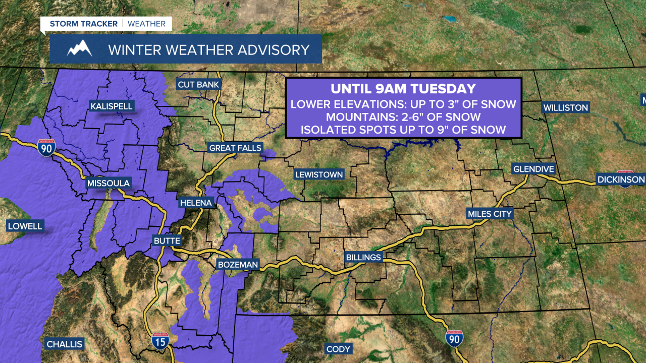
A WINTER WEATHER ADVISORY is in effect for western Montana and some of the mountains in central and southwestern Montana until 9am Tuesday.

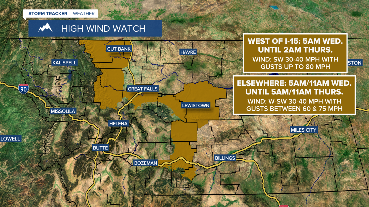
A HIGH WIND WATCH is in effect for the Rocky Mountain Front out to I-15 from 5am Wednesday until 2am Thursday, and for portions of central and south-central Montana, including Great Falls, Judith Gap, Lewistown, and Livingston, from 5am/11am Wednesday until 5am/11am Thursday.

There are going to be scattered areas of light snow around this evening and tonight, generally in locations east of I-15 and especially before midnight, as a disturbance passes through our area. We are then going to have mostly to partly cloudy skies tomorrow with a few snow showers around, mainly during the morning and mainly along the eastern half of the Hi-Line, as this disturbance leaves our area.
Through midday tomorrow, up to 5” of snow accumulation is possible in the mountains and up to 1” of snow accumulation is possible in the lower elevations (although most lower elevation locations will receive a coating or less of snow accumulation). Be prepared for slippery roads when traveling tonight and tomorrow morning, especially at and above mountain pass level. Also, the graphic below shows the possible snow accumulation from this evening through midday tomorrow.

There are then going to be scattered areas of primarily snow around tomorrow night, especially after midnight and especially in locations east of I-15, as the next disturbance begins to impact our area. On Wednesday, we are going to have partly to mostly cloudy skies with scattered areas of snow and rain around, mainly along the Rocky Mountain Front and along the Continental Divide as well as along the Hi-Line and in eastern portions of north-central Montana, as this disturbance continues to impact our area.
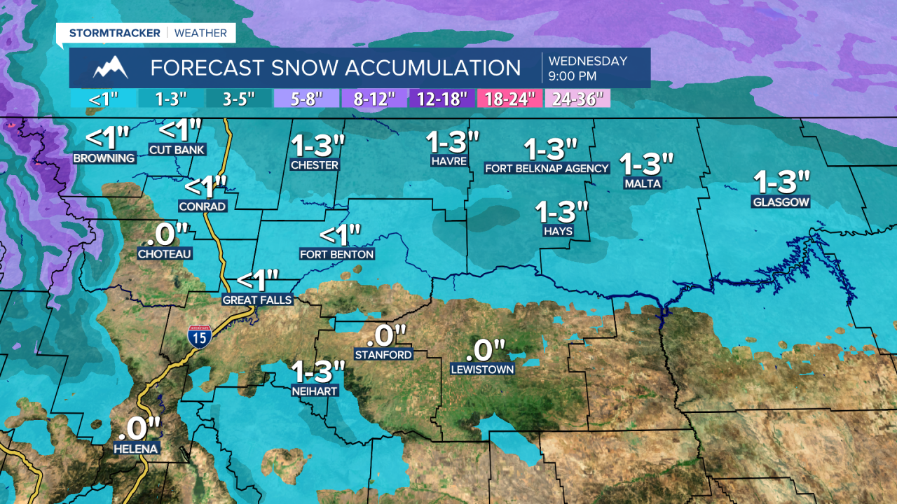
In the lower elevations, up to 2” of snow accumulation is possible from tomorrow night through Wednesday evening, with the highest snow amounts expected along the Hi-Line east of I-15. In the Rockies, up to a foot of snow accumulation is possible tomorrow evening through Wednesday evening, with up to 18” of snow possible on the highest peaks. In the other mountain ranges, less than 3” of snow is expected with this disturbance. Again, be prepared for slippery roads when traveling, especially at and above mountain pass level. Also, the graphic below shows the possible snow accumulation from tomorrow evening through Wednesday evening.

It is also going to be chilly tonight and tomorrow as lows tonight are going to be in the teens and 20s, and highs tomorrow are going to be in the 20s and mid to upper teens in north-central Montana, with highs in the 30s around Helena. Warmer temperatures are then expected on Wednesday as highs are going to be in the 40s and low to mid 50s in a lot of locations (highs in the 30s and upper 20s along the eastern half of the Hi-Line).
There is also going to be little to no wind around through tomorrow. We are then going to have increasing wind in some areas tomorrow night, with widespread gusty to strong winds around on Wednesday. The strongest wind on Wednesday will be along the Rocky Mountain Front and out to I-15 as well as in central Montana, including around Great Falls, Lewistown, and Stanford, where gusts over 60 mph are likely, and gusts up to 80 mph are possible at times. This wind will be strong enough to create difficult travel conditions and cause some wind damage, including downed tree limbs/power lines and blowing/flying debris. The further east in north-central Montana you go, the weaker the wind will be, but the wind will get stronger as the day goes on, with gusts up to 50 mph possible in eastern portions of north-central Montana later Wednesday into Wednesday night.
We are then going to have partly to mostly sunny skies and mainly dry conditions on Thursday and Saturday, and partly to mostly cloudy skies and mainly dry conditions on Friday as an upper-level ridge is going to be in control of our weather. Thursday will feature little to no wind, but it will be a bit breezy in some areas on Friday and Saturday as sustained wind speeds are going to be between 10 and 20 mph. It is also going to be cooler on Thursday than it is going to be on Wednesday as highs are going to be in the teens and 20s along the Hi-Line east of I-15 and highs are going to be in the 30s and low to mid 40s elsewhere. The temperatures are then going to warm back up for Friday and Saturday as highs are going to be in the 40s and low to mid 50s in most locations (highs in the mid to upper 20s and low to mid 30s along the eastern half of the Hi-Line).
On Sunday, there is going to be some snow and rain around, generally in western and southern Montana, with only isolated rain and snow showers expected in north-central Montana. We are also going to have decreasing clouds and pleasant temperatures on Sunday as highs are going to be in the 40s and low 50s (highs in the 30s in northeastern Montana). Gusty winds are also expected in some areas on Sunday as sustained wind speeds are going to be between 10 and 30 mph.
We are then going to have partly cloudy skies, mostly dry conditions, and mild temperatures on Monday as highs are going to be in the upper 30s, 40s, and low 50s. It is also going to be windy in some areas on Monday as sustained wind speeds are going to be between 15 and 30 mph.


