An AIR QUALITY ALERT is in effect for portions of southwestern Montana until at least 8am Wednesday.

A WINTER WEATHER ADVISORY is in effect for the Butte/Blackfoot region and the Bitterroot/Sapphire mountains above 6500 feet from 12am Thursday until 6am Friday.

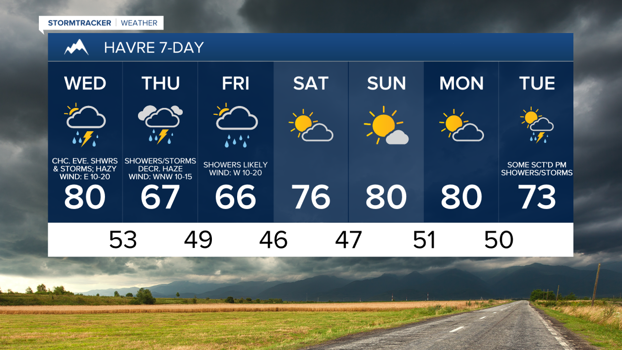
Smoke from wildfires burning in Idaho and southwestern Montana will continue to impact much of Montana through Wednesday night. Most of this smoke is going to be aloft in the atmosphere, so the visibility will be reduced, but the air quality won’t be impacted too much (moderate or good air quality for most). However, there are going to be some areas of thicker smoke around tonight and tomorrow in western and southwestern Montana, and this is where the air quality may be unhealthy for sensitive groups and/or unhealthy for everyone at times. The haze/smoke will then decrease for everyone as we head into Thursday and Friday as a storm system passes through our area.
We are going to have partly to mostly cloudy skies tonight with a few showers and isolated thunderstorms around. We are also going to have pleasant temperatures tonight as lows are going to be in the 50s and mid to upper 40s in most locations.
For tomorrow, we are going to have mostly cloudy skies (via increasing clouds) with showers and thunderstorms likely, generally during the afternoon/evening and generally in western and central Montana, as a storm system begins to impact our area. A couple severe thunderstorms with damaging winds (58+ mph) and/or large hail (1+” in diameter) are also possible later on tomorrow. There are then going to be more scattered showers and thunderstorms around tomorrow night.
There is also going to be a bit of a breeze around tomorrow along portions of the Hi-Line as sustained wind speeds are going to be between 10 and 20 mph. It is also going to be mild/warm tomorrow as highs are going to be in the 70s and low to mid 80s.
There are then going to be showers and some thunderstorms around on Thursday in central and western Montana and there are going to be scattered showers and thunderstorms around on Thursday in eastern Montana as this storm system continues to impact our area. Some severe thunderstorms with damaging winds and/or large hail are also possible Thursday afternoon/evening in eastern Montana. Widespread showers and a few thunderstorms are also expected Thursday night and Friday, with the precipitation gradually moving eastward and gradually tapering off from west to east as we go through Thursday night and Friday as the storm system begins to pull away from our area. We are also going to have mostly cloudy to overcast skies on Thursday and mostly to partly cloudy skies (via decreasing clouds) on Friday.
The highest precipitation amounts from tomorrow afternoon through Friday evening are going to be in western Montana. This is where most locations will receive at least 1” of precipitation, and a few locations may receive over 2” of precipitation. The further east in the state you go, the lower the precipitation amounts will be with most locations in eastern Montana receiving less than .25” of precipitation. In north-central Montana, most locations will receive between .5" and 1.5" of precipitation. Isolated higher precipitation amounts are also possible in locations that receive heavy rainfall from thunderstorms. This is especially true for locations in eastern Montana where the most thunderstorm activity is expected. It is also going to be cold enough for some snow in the mountains above 6500 feet, and a few to several inches of snow accumulation is possible, especially in the mountains in southwestern Montana.

We are also going to have a wide range of temperatures on Thursday as highs are going to range from the mid 50s to the mid 70s, with the warmest temperatures in northeastern Montana. It is then going to be cool for everyone on Friday as highs are going to be in the 60s in most locations. There is also going to be a bit of a breeze around in some areas on Thursday and Friday as sustained wind speeds are going to be between 10 and 20 mph.
Beautiful weather is then expected this weekend as we are going to have partly cloudy skies and dry conditions on Saturday and mostly sunny skies and dry conditions on Sunday. It is also going to be warmer this weekend than it is going to be on Thursday and Friday as highs are going to be in the 70s and low 80s in most locations. There is also going to be a bit of a breeze around on Saturday as sustained wind speeds are going to be between 10 and 20 mph.
We are then going to have mostly cloudy skies on Monday with a few showers and thunderstorms around during the afternoon and evening, mainly around the Helena area, as a disturbance passes through our area. There are then going to be scattered showers and a few thunderstorms around on Tuesday as a stronger disturbance passes through our area. We are also going to have mostly cloudy skies on Tuesday. The temperatures are also going to cool down some early next week as highs are going to be in the 70s and low to mid 80s on Monday and the 60s and low to mid 70s on Tuesday.