An EXTREME COLD WARNING is in effect for portions of southwestern Montana and portions of Blaine and Hill Counties until 11am Thursday.
A COLD WEATHER ADVISORY is in effect for most of Montana until 11am Thursday.
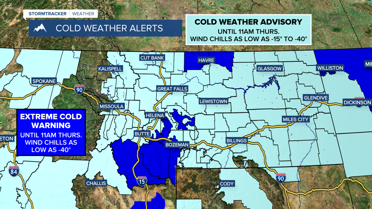
A WINTER WEATHER ADVISORY is in effect for western/central Glacier County and western/central Pondera County until 9am Thursday.

Gusty winds are expected tonight along the Rocky Mountain Front and in Glacier County as sustained wind speeds are going to be between 15 and 30 mph, and wind gusts over 40 mph are possible. It is also going to be breezy tonight in portions of the plains as sustained wind speeds are going to be between 10 and 20 mph. This wind will cause there to be some areas of blowing and drifting snow around, especially along the Rocky Mountain Front and along MT-200 in Cascade County and Judith Basin County, so please use caution when driving.
Frigid temperatures are also expected again tonight, although it will be a little warmer than it was last night as lows are going to be in the -0s and -10s in most spots (there will be some -20s along the Hi-Line), and wind chills are going to be in the -10s, -20s, and -30s (coldest along the Hi-Line). We are also going to have mainly clear skies tonight.
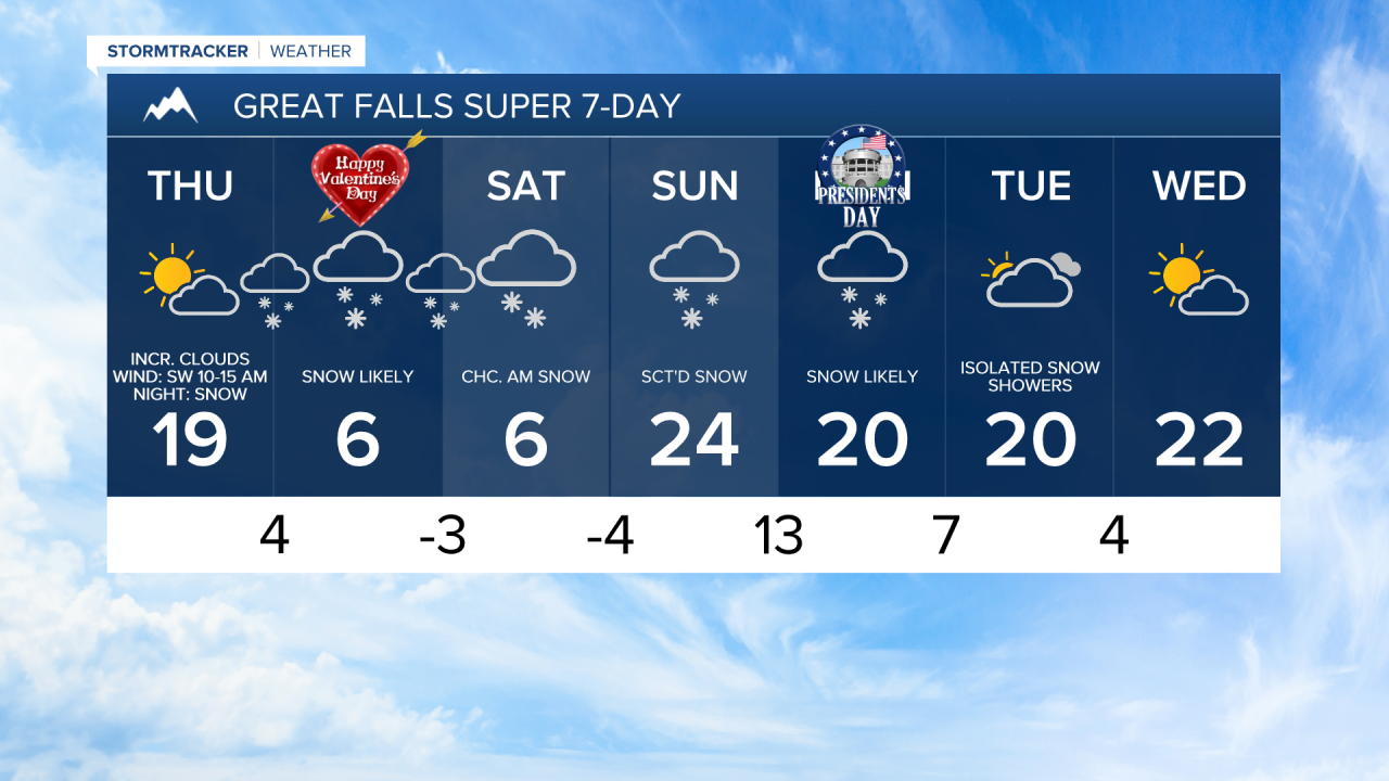
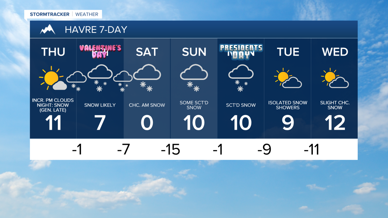
For tomorrow, we are going to have increasing clouds from southwest to northeast with some snow beginning to develop around Helena during the evening (generally after dark). It is also going to be warmer tomorrow than it has been over the past several days as highs are going to range from the upper single digits to the low 20s, with most of us topping out in the teens. Wind chills are also going to warm up some as we go through tomorrow as wind chills are going to be in the -10s, -20s, and -30s during the morning, and the 0s and -0s during the afternoon/evening. There is also going to be a little breeze around in some areas tomorrow morning as sustained wind speeds are going to be between 5 and 20 mph.
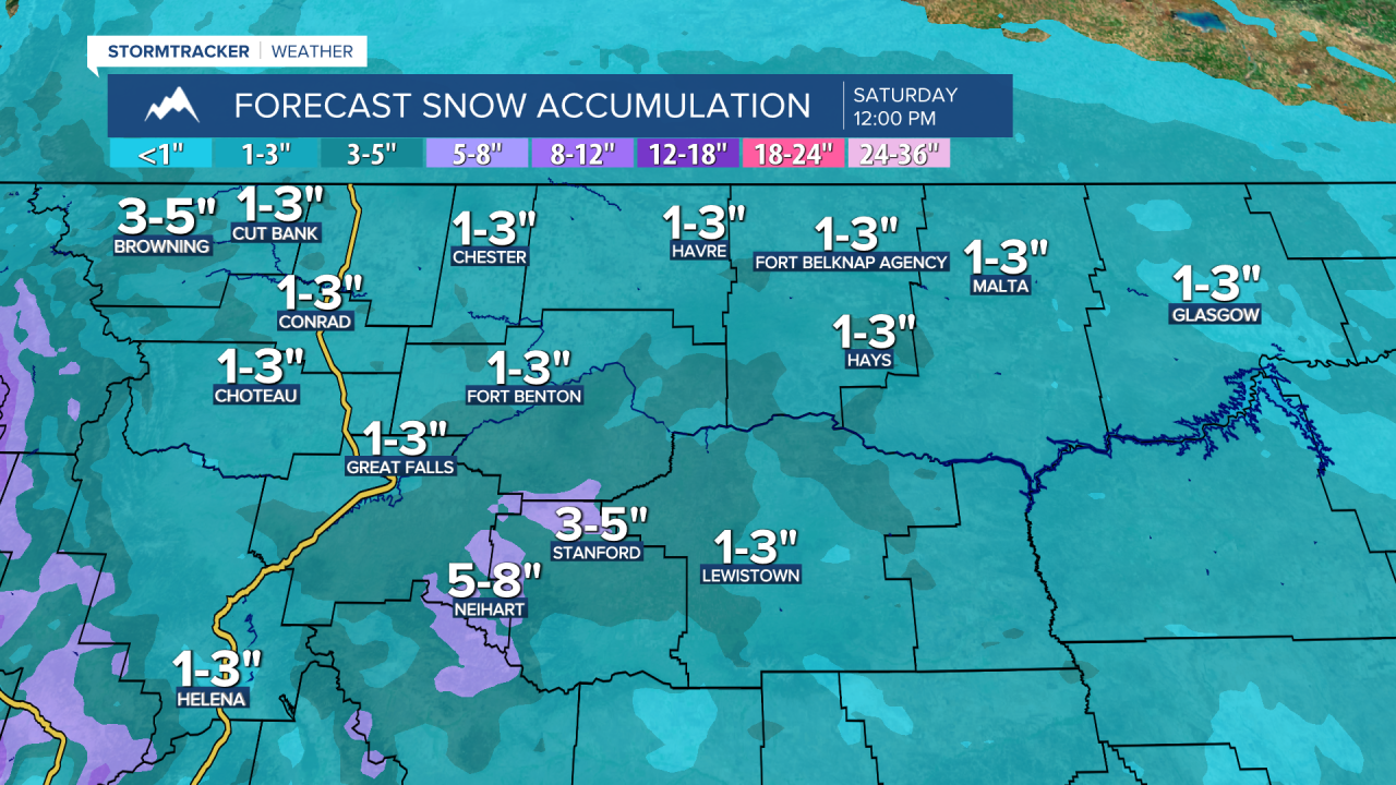
There are then going to be areas of snow around from tomorrow night through Saturday morning as a disturbance passes through our area. This snow will be off-and-on, so there will be breaks in the snow. As we go through Saturday, this snow will taper off from west to east. Most locations will receive 1-5” of snow from this disturbance. In the mountains, up to 8” of snow is possible, especially in the Highwoods and Little Belts.
It is also going to be frigid on Friday and Saturday as highs are only going to be in the single digits in most locations, although the temperatures will warm up into the teens on Saturday around Helena. There is also going to be a little breeze around in some areas on Friday as sustained wind speeds are going to be between 5 and 20 mph.
There is then going to be scattered snow around on Sunday and widespread snow is likely on Monday as another storm system impacts our area. It is also going to be warmer in central Montana and in western portions of north-central Montana, including around Cut Bank, Great Falls, Helena, and Lewistown, on these two days as highs are going to be in the teens and 20s. In the rest of north-central Montana, it will continue to be very cold on these two days as highs are going to be in the single digits and low to mid teens.
We are then going to have mostly cloudy skies on Tuesday with snow likely around Helena and a few snow showers around in north-central Montana as the Sunday/Monday disturbance begins to depart our area. On Wednesday, we are going to have partly to mostly cloudy skies with some isolated snow showers around. It is also going to continue to be cold on these two days as highs are going to be in the single digits, teens, and low 20s in north-central Montana and the 20s around Helena.