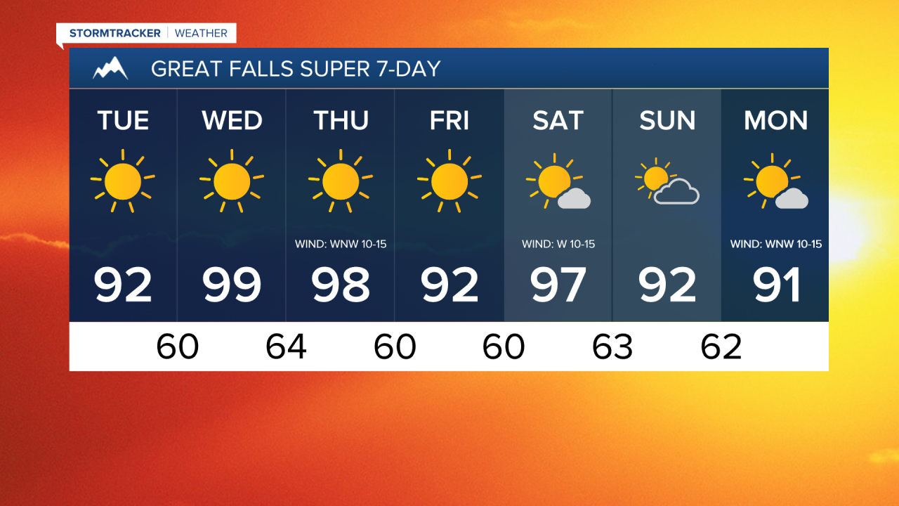
OVERVIEW: Lots of sunshine, mainly dry conditions, and above average temperatures are expected through Friday as an upper-level ridge is going to be in complete control of our weather. This weekend, the upper-level ridge will continue to be in control of our weather, but a few weak disturbances will pass through our area producing a little more cloud cover and a small chance for showers and thunderstorms, generally in the mountains. We are also going to continue to have above average temperatures this weekend.

DAY-TO-DAY: We are going to have mainly clear skies and mild temperatures tonight as lows are going to be in the 50s and low 60s. For tomorrow, we are going to have mostly sunny skies west of I-15 and mainly sunny skies east of I-15. It is also going to be hot again tomorrow as highs are going to be in the mid to upper 80s and low to mid 90s in most locations.
Lots of sunshine and mainly dry conditions are then expected on Wednesday, Thursday, and Friday. It is also going to be really hot on Wednesday and Thursday as highs are going to be in the 90s and 100s, and a few locations may set new record high temperatures on one or both of these days. It is then going to be slightly cooler, but still hot on Friday as highs are going to be in the 90s and upper 80s. There is also going to be a bit of a breeze around on Wednesday along and just east of the Continental Divide and there is going to be a bit of a breeze around in most locations on Thursday as sustained wind speeds are going to be between 10 and 20 mph. This wind coupled with hot temperatures and low relative humidity will elevate the fire danger, so please do your part to not start any new fires.
For this weekend, we are going to have partly to mostly sunny skies on Saturday and partly cloudy skies on Sunday as a couple disturbances pass through our area. Most locations will also continue to remain dry this weekend, but there is a slight chance that we could see a couple showers and thunderstorms during the PM hours on both days, especially around the Helena area. It is also going to continue to be hot this weekend as highs are going to be in the 90s on Saturday and the mid to upper 80s and low to mid 90s on Sunday. There is also going to be a bit of a breeze around this weekend as sustained wind speeds are going to be between 10 and 20 mph, and this wind will create elevated fire danger.
On Monday, we are going to have mostly sunny skies with a slight chance of PM showers and thunderstorms as another weak disturbance passes through our area. It is also going to be hot and a little breezy on Monday as highs are going to be in the mid to upper 80s and low to mid 90s and sustained wind speeds are going to be between 5 and 20 mph.