HIGH WIND ALERTS are in effect for portions of central and south-central Montana from 3am/6am until 3pm/6pm Saturday.

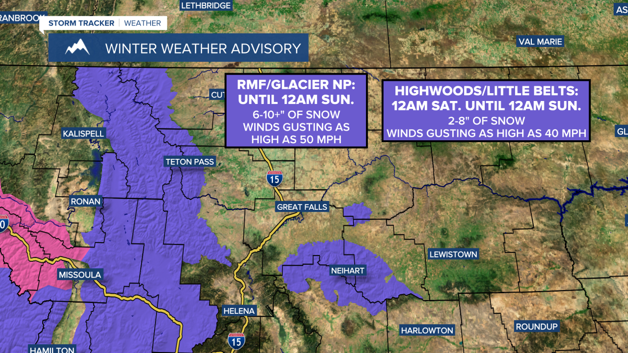
A WINTER WEATHER ADVISORY is in effect for the Rocky Mountain Front and Glacier National Park until 12am Sunday.
A WINTER WEATHER ADVISORY is in effect for the Highwoods and Little Belts from 12am Saturday until 12am Sunday.
The wind is going to diminish as we go through this evening. It is then just going to be a little breezy tonight in most locations as sustained wind speeds are going to be between 5 and 20 mph. Along the Rocky Mountain Front and in central Montana, including around the Little Belts, it is going to continue to be breezy tonight, especially during the second half of the night, as sustained wind speeds are going to be between 10 and 25 mph. It is then going to be windy tomorrow around the Helena area and in southern portions of north-central Montana as sustained wind speeds are going to be between 15 and 35 mph, and wind gusts over 50 mph are possible. Elsewhere in north-central Montana, it is going to be breezy/gusty tomorrow as sustained wind speeds are going to be between 10 and 25 mph, and wind gusts up to 40 mph are possible.
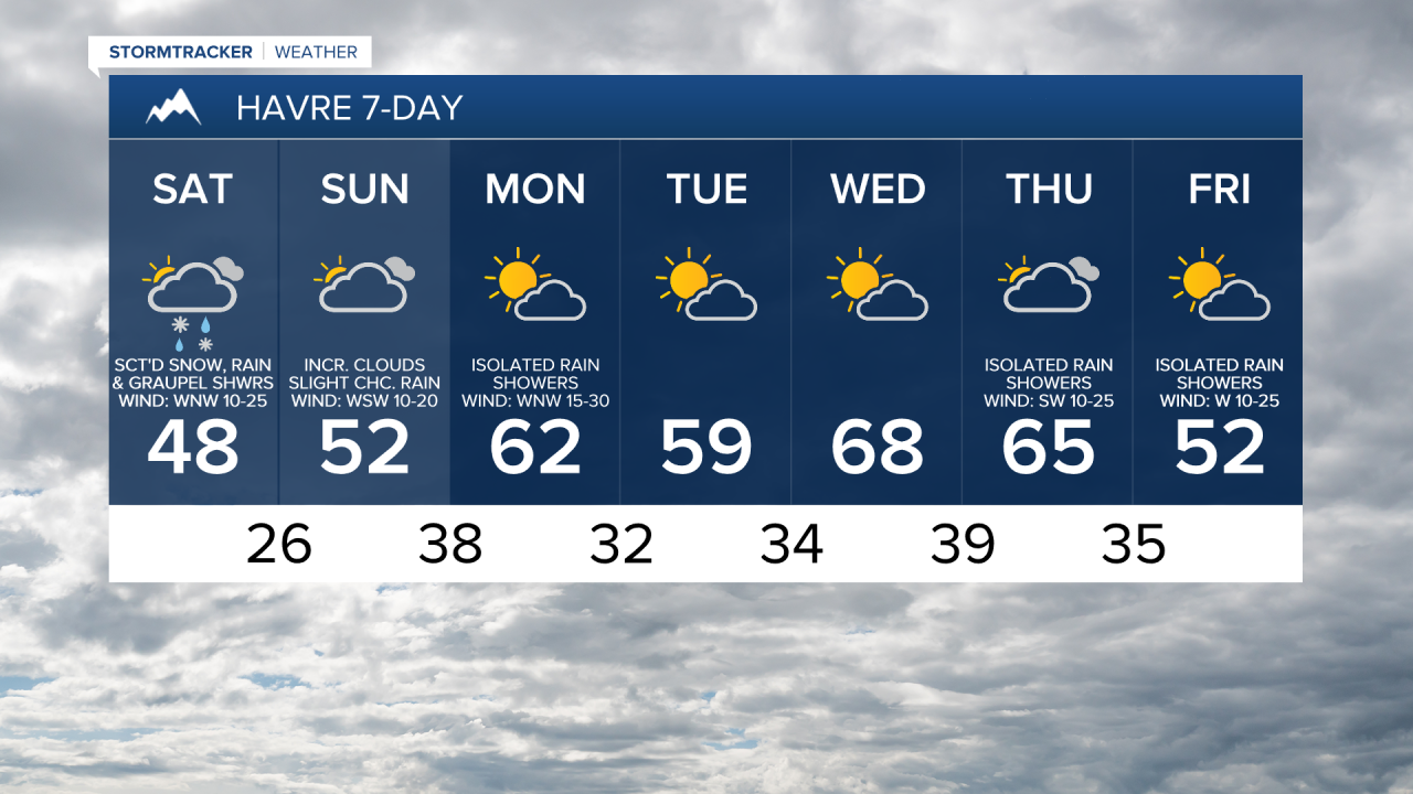
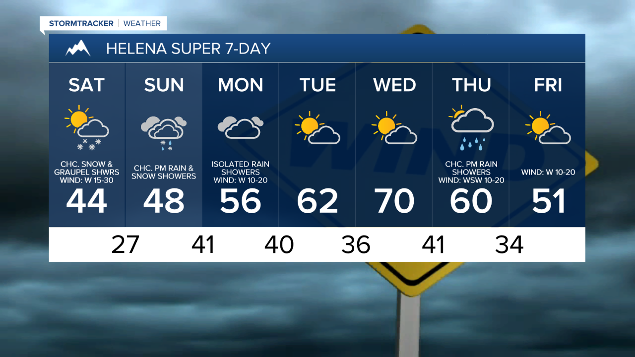
There are also going to be scattered snow, graupel, and rain showers around tonight (generally after midnight) and tomorrow as another disturbance passes through our area. Along the Divide, periods of heavy snow are expected tonight and tomorrow. In the lower elevations, up to 2” of snow is possible, but most locations will receive little (a coating) to no snow accumulation.
In the northern part of the Rockies, including the Scapegoat Wilderness and Glacier National Park, 6-18” of snow is expected, with up to 2 feet of snow possible on the highest peaks. In the Rockies south of the Scapegoat Wilderness and in the mountains in central Montana, 2-12” of snow is expected. This snow will make for slick road conditions at and above mountain pass level, especially late tonight and tomorrow morning, so please use caution if you are going to be traveling over any of the mountain passes in western Montana, and consider delaying travel until later tomorrow if your travels will take you over Lookout Pass or Marias Pass.

We are also going to have partly to mostly cloudy skies tonight and tomorrow. Tonight, lows are going to be in the upper 20s and low to mid 30s. Tomorrow is then going to be the coolest day of the next week as highs are going to range from the mid 30s to the low 50s.
We are then going to have mostly cloudy skies on Sunday with some scattered rain/snow showers around the Helena area, generally during the PM hours, and a few isolated rain and snow showers around in north-central Montana as the next disturbance begins to approach our area. The wind is also going to be weaker on Sunday than it is going to be tomorrow, but it is still going to be breezy as sustained wind speeds are going to be between 10 and 25 mph. It is also going to be warmer on Sunday than it is going to be tomorrow as highs are going to be in the 40s and low to mid 50s.
Another round of gusty to strong winds is then expected on Monday as sustained wind speeds are going to be between 15 and 35 mph, and wind gusts up to 50 mph are possible, with even stronger wind expected along the Rocky Mountain Front. We are also going to have mostly cloudy skies on Monday with a few rain showers around, generally in the mountains and in locations east of I-15. Warmer temperatures are also expected on Monday as highs are going to be in the mid to upper 50s and low to mid 60s.

An upper-level ridge is then going to provide us with beautiful weather on Tuesday and Wednesday as we are going to have partly cloudy skies, mainly dry conditions, less wind (sustained wind speeds between 5 and 20 mph), and well above average temperatures for this time of year as highs are going to be in the mid to upper 50s and low to mid 60s on Tuesday and the mid to upper 60s and low to mid 70s on Wednesday.
Cooler temperatures will then return for the end of next week as highs are going to be in the 60s and upper 50s on Thursday and the mid to upper 40s and low to mid 50s on Friday. Gusty winds are also going to return later next week as sustained wind speeds on Thursday and Friday are going to be between 10 and 30 mph, and wind gusts over 40 mph are possible. We are also going to have partly to mostly cloudy skies on these two days with a few rain and snow showers around the Helena area, generally in the mountains, and some isolated rain and snow showers around in north-central Montana.