


A HEAT ADVISORY is in effect for western Montana until 12am Thursday and for portions of central Montana until 9pm Thursday.
An EXCESSIVE HEAT WARNING is in effect for eastern Montana until 9pm Thursday.

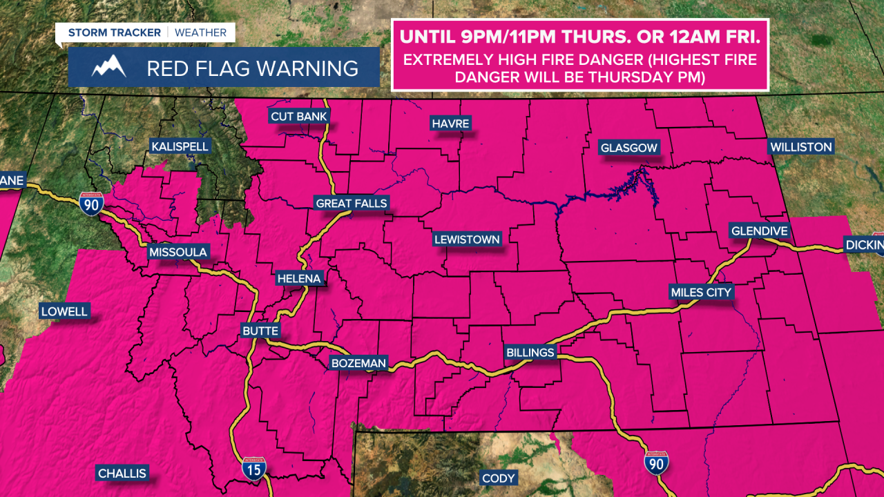
A RED FLAG WARNING is in effect for most of Montana until 9pm/11pm Thursday or 12am Friday.
There are going to be some scattered showers and thunderstorms around this evening and tonight as a disturbance passes through our area. A couple severe thunderstorms with strong winds are also possible this evening and tonight. We are also going to have partly to mostly cloudy and hazy skies tonight. It is also going to be warm tonight as lows are going to be in the 60s and low to mid 70s.

There are then going to be some more scattered showers and thunderstorms around tomorrow, generally during the PM hours and mainly in locations east of I-15 as a cool front passes through our area. A couple severe thunderstorms with strong winds are also possible again tomorrow. We are also going to have partly to mostly sunny skies tomorrow.

Tomorrow is also going to be the windiest day that we have had in a while as sustained wind speeds are going to be between 10 and 30 mph, and wind gusts up to 50 mph are possible. Due to the combination of hot temperatures, low relative humidity, gusty winds, and lightning/outflow winds from thunderstorms, the fire danger tomorrow is going to be extremely high, so please do your part to not start any new fires. New fire starts from lightning are also likely tonight and tomorrow, so make sure you alert the proper authorities if you see any new smoke.
It is also going to be hot again tomorrow, although it will be slightly cooler than it was today as highs are going to range from the mid 80s to the 100s, with the hottest temperatures in eastern Montana.
Cooler temperatures are then expected Friday and this weekend as highs are only going to be in the 80s and low 90s. We are also going to have mostly sunny/hazy skies and mostly dry conditions on these three days. It is also going to be a bit breezy on Friday and Sunday as sustained wind speeds are going to be between 10 and 20 mph.
Lots of sunshine and mainly dry conditions are then expected on Monday and Tuesday as high pressure is going to be in control of our weather. We are then going to have mostly sunny skies on Wednesday with a slight chance of showers and thunderstorms as a disturbance passes through our area. It is also going to be very warm to hot and breezy on these three days as highs are going to be in the mid to upper 80s and low to mid 90s, and sustained wind speeds are going to be between 10 and 20 mph.


