An EXTREME COLD WARNING is in effect for most of north-central Montana and all of northeastern Montana until 11am/12pm Wednesday.
A COLD WEATHER ADVISORY is in effect for the valleys in Meagher County and portions of south-central and southeastern Montana until 12pm Wednesday.

A WINTER STORM WATCH is in effect for the Rocky Mountain Front and the Cut Bank area from 5am/5pm Thursday until 5am Saturday.

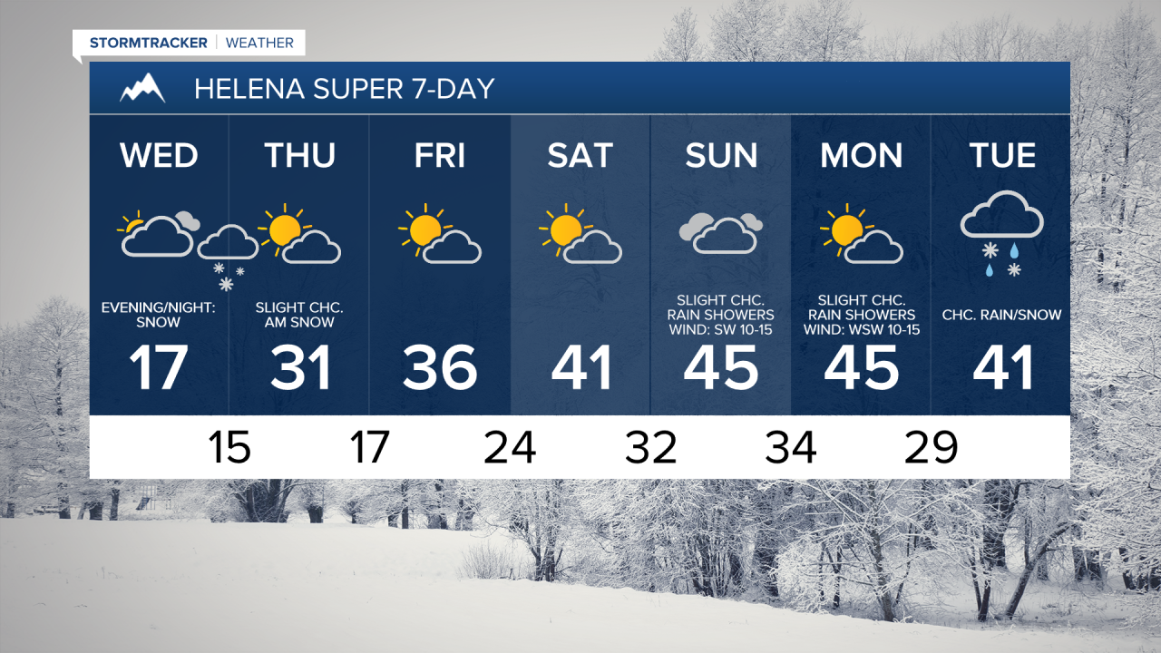
The end of sub-zero temps is near, but we have one more extremely cold night to get through. Lows tonight are going to be in the -20s and -30s in north-central Montana and the -0s and -10s around Helena. Dangerously cold wind chills are also expected tonight and tomorrow morning as wind chills are going to be in the -30s, -40s, and -50s in north-central Montana, and the -0s, -10s, and -20s around Helena. Please try and limit your time outdoors tonight and tomorrow morning, and if you have to be outside, make sure you wear multiple layers and cover all exposed skin.
Due to this extreme cold, multiple school districts have announced delays for Wednesday, February 19, 2025, and these changes can be found by clicking here.
We are also going to have mostly clear skies tonight with patchy fog around. There is also going to be a little breeze (sustained wind speeds between 5 and 20 mph) around tonight along portions of the Hi-Line.
For tomorrow, we are going to have increasing clouds throughout the day with some snow developing around Helena and along the Divide during the evening. Snow is then likely tomorrow night around Helena, in the mountains in central Montana, and along the Divide as a disturbance passes through our area. In the lower elevations, a coating-3” of accumulation is possible, and in the mountains, up to 5” of accumulation is possible. In north-central Montana, most locations will remain dry tomorrow night, but a few snow showers are possible, generally along the Rocky Mountain Front and in Cascade/Fergus/Judith Basin Counties.

It is also going to be cold again tomorrow, but it will be a little warmer than it was today as highs are going to be in the -0s and 0s in north-central Montana and the mid to upper teens and low to mid 20s in central Montana, including around Helena and Lewistown. There is also going to be a breeze around tomorrow along the Hi-Line and in eastern portions of north-central Montana as sustained wind speeds are going to be between 10 and 25 mph.
We are then going to have partly cloudy skies on Thursday with a few snow showers around during the morning in central Montana, including around Helena, as tomorrow night’s disturbance leaves our area. It is also going to be gusty on Thursday along the Divide and along the Rocky Mountain Front as wind gusts over 50 mph are possible, and this wind will cause there to be blowing and drifting snow, which may create ground blizzard conditions. Elsewhere, it is going to be a little breezy on Thursday as sustained wind speeds are going to be between 5 and 20 mph. Much warmer air will also arrive on Thursday as highs are going to be in the 20s and 30s in most locations (teens along the eastern half of the Hi-Line).
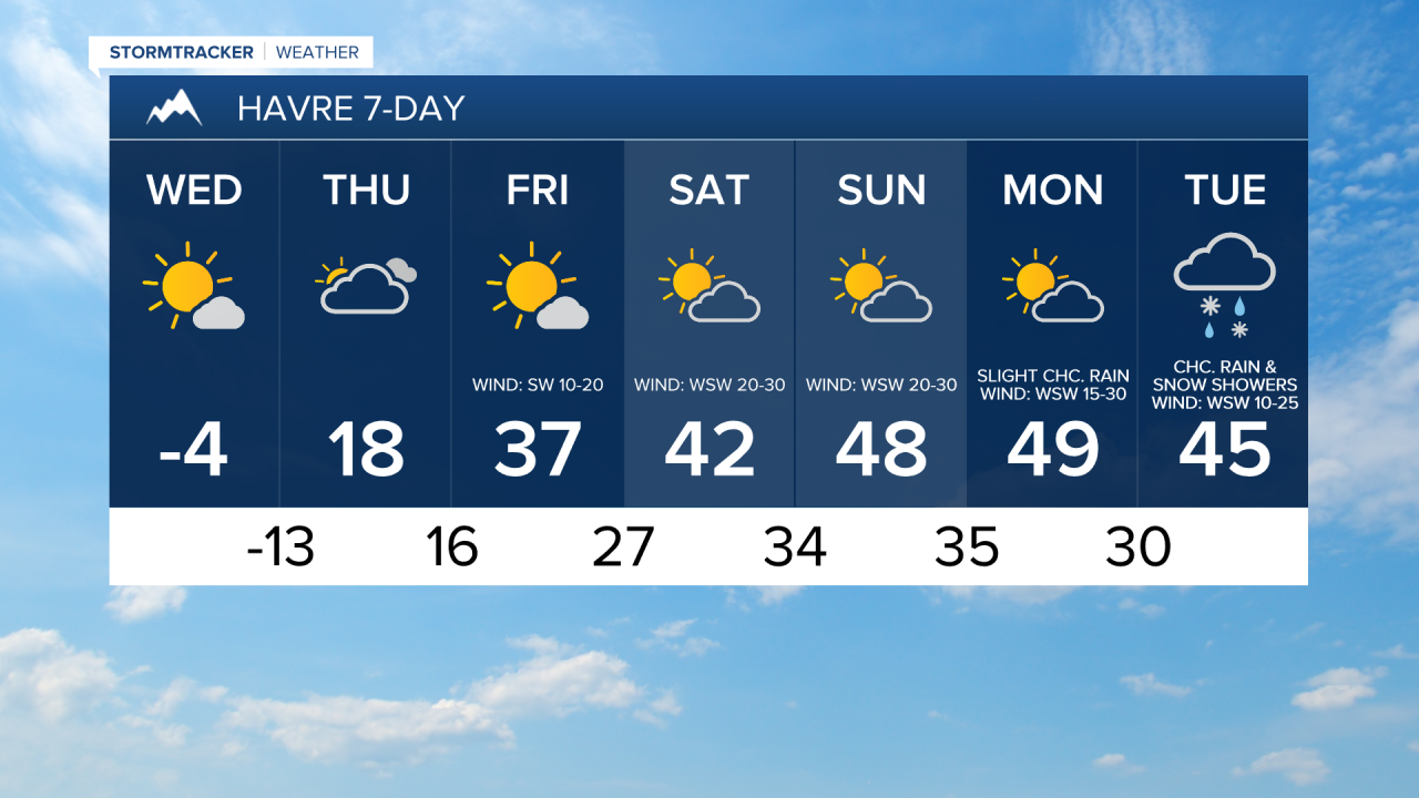
Significantly warmer temperatures are then expected Friday and this weekend as highs are going to be in the 30s and low 40s on Friday; the mid to upper 30s and low to mid 40s on Saturday; and the 40s and low 50s on Sunday. These warm temperatures are going to be accompanied by a lot of wind though. Along the Rocky Mountain Front, it is going to be very windy Friday and this weekend as sustained wind speeds are going to be between 30 and 50 mph, and wind gusts up to 70 mph are possible. Ground blizzard conditions are also possible along the Rocky Mountain Front from Thursday night through Saturday due to blowing/drifting snow from this wind.
East of the Rocky Mountain Front, it is going to be breezy on Friday as sustained wind speeds are going to be between 10 and 25 mph. It is then going to be windy this weekend as sustained wind speeds are going to be between 15 and 35 mph, and wind gusts over 50 mph are possible. The Helena Valley will see little to no wind on Friday and Saturday. It will then be a little breezy on Sunday as sustained wind speeds are going to be between 5 and 20 mph.
We are also going to have partly cloudy skies and dry conditions on Friday and Saturday. We are then going to have mostly cloudy skies on Sunday with some isolated rain and snow showers around, generally in the mountains, as a disturbance passes through our area.
It is going to remain mild early next week as highs are going to be in the 40s and low 50s on Monday and the 40s and upper 30s on Tuesday. It is also going to continue to be gusty/windy early next week as sustained wind speeds are going to be between 15 and 35 mph on Monday and 10 and 30 mph on Tuesday. We are also going to have partly cloudy skies with a few isolated rain and mountain snow showers around on Monday. There are then going to be some scattered rain and snow showers around on Tuesday as a disturbance passes through our area.