An EXTREME COLD WARNING and a COLD WEATHER ADVISORY are in effect for portions of north-central and northeastern Montana until 11am Thursday.

It is going to be frigid again tonight as lows are going to be in the -10s and -20s along the Hi-Line, and the -0s and 0s south of the Hi-Line. One positive about tonight is that in central Montana and in portions of north-central Montana, the lows will occur early on tonight, with the temperatures warming up some as the night goes on. Dangerously cold wind chills are also expected again tonight, especially in northeastern Montana and along the Hi-Line east of I-15, as wind chills as low as -45° are possible.
It is also going to be gusty tonight in the mountains and along the Rocky Mountain Front as gusts over 40 mph are possible. There is also going to be a breeze around tonight in portions of the plains as sustained wind speeds are going to be between 10 and 20 mph. This wind will cause there to be some areas of blowing and drifting snow. We are also going to have partly cloudy to mostly clear skies tonight with isolated snow showers around, generally in the mountains.
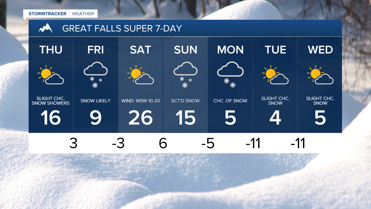
For tomorrow, we are going to have partly to mostly sunny skies with a few snow showers around, generally in the mountains. It is also going to be warmer tomorrow than it has been over the past several days as highs are going to be in the 0s, 10s, and low to mid 20s. There is also going to be a bit of a breeze around tomorrow in the mountains and along the Rocky Mountain Front as sustained wind speeds are going to be between 10 and 20 mph.
Snow will then begin to develop in central Montana and southern portions of north-central Montana later tomorrow night as the next disturbance begins to approach our area. There is then going to be widespread light to moderate snow around on Friday, generally in locations south of the Hi-Line, as this disturbance passes through our area.
The lowest snow amounts with this disturbance will be along the Hi-Line where 0-2” of snow is expected. In central Montana, including around Great Falls, Helena, and Lewistown, 2-6” of snow is expected, with isolated spots receiving up to 8” of snow. Roads will be slick/snow-covered throughout a lot of the state on Friday, and there will be areas of low visibility as well, so please be careful when driving and give yourself some extra time to get to where you need to go.

It is also going to be very cold on Friday as highs are going to be in the single digits and low to mid teens.
For this weekend, we are going to have partly to mostly sunny skies and mostly dry conditions on Saturday, and partly to mostly cloudy skies with scattered snow around on Sunday, especially during the PM hours. It is also going to be a bit warmer, but still pretty cold this weekend as highs are going to be in the teens and low to mid 20s, with Saturday being the warmer day. There is also going to be a breeze around on Saturday as sustained wind speeds are going to be between 10 and 20 mph.
There is then going to be some more scattered light snow around on Monday, especially in the mountains. Isolated snow showers are then possible on Tuesday and Wednesday, especially in the mountains. We are also going to have partly to mostly cloudy skies on these three days. Arctic air also returns next week as highs are going to be back in the 0s and -0s.