A SEVERE THUNDERSTORM WATCH is in effect for portions of northeastern Montana until 11pm Thursday.

A RED FLAG WARNING is in effect for most of Montana until 9pm/11pm Thursday or 12am Friday.

A RED FLAG WARNING is in effect for portions of the Hi-Line from 12pm until 9pm Friday.

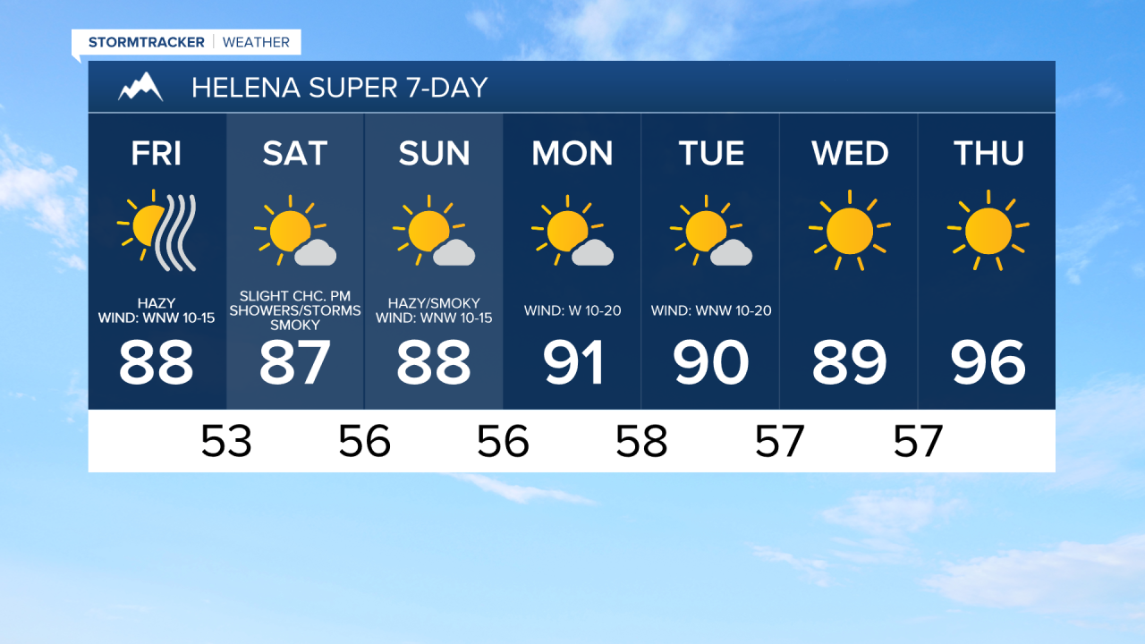
Widespread haze is expected through at least this weekend as smoke from wildfires burning locally, in Canada, and in the Pacific Northwest continues to impact our area. It is also going to be smoky at times over the next few days (especially on Saturday), and this smoke will cause the air quality to be unhealthy for sensitive groups or unhealthy for everyone at times, so you may want to limit your time outdoors over the next few days.
There are going to be some scattered showers and thunderstorms around this evening and early tonight in locations east of I-15 as a cold front continues to work its way eastward through the state. A couple severe thunderstorms with damaging winds (wind gusts up to 75 mph) and/or large hail (up to 1.5" in diameter) are also possible through early tonight. We are also going to have decreasing clouds tonight.
The wind is also going to diminish some this evening. It is then going to be breezy in some areas tonight as sustained wind speeds are going to be between 10 and 20 mph. It is also going to be a lot cooler tonight than it was last night as lows are going to be in the 50s and upper 40s in most locations.
For tomorrow, we are going to have lots of sunshine, dry conditions, and cooler temperatures as highs are going to be in the 80s in most locations. The wind is also going to be weaker tomorrow than it was today, but it is still going to be breezy as sustained wind speeds are going to be between 10 and 20 mph, and the strongest wind is going to be along the Rocky Mountain Front and along the Hi-Line.
We are then going to have lots of sunshine and mainly dry conditions on Saturday in north-central Montana, and we are going to have increasing clouds with isolated PM showers and thunderstorms on Saturday around the Helena area. It is also going to be very warm on Saturday as highs are going to be in the mid to upper 80s and low 90s in most locations.
Partly to mostly sunny skies are then expected on Sunday as a disturbance passes through our area. A couple isolated showers and thunderstorms are also possible on Sunday, but most locations are going to remain dry. It is also going to be warm and a bit breezy on Sunday as highs are going to be in the 80s and low 90s, and sustained wind speeds are going to be between 10 and 20 mph.
Mostly sunny skies and mostly dry conditions are then expected next week as high pressure is going to be in control of our weather. It is also going to be very warm to hot next week as highs are going to be in the 80s and low to mid 90s on Monday, Tuesday, and Wednesday, and highs are going to be in the 90s and upper 80s on Thursday. There is also going to be a breeze around on most days next week as sustained wind speeds are going to be between 10 and 20 mph.