


There is going to be widespread haze and a few areas of near-surface smoke around tonight, but this haze/smoke will decrease some as the night goes on. For tomorrow, it will be hazy throughout the day in southwestern and south-central Montana (including around Butte, Bozeman, and Helena); we are going to have decreasing haze in eastern Montana; and we are going to have good air quality and just a little haze in northwestern and north-central Montana. The haze will then increase some as we head into Friday, especially in western Montana, but it should not impact the air quality all that much.
We are going to have mostly cloudy skies and mainly dry conditions tonight. It is also going to be mild tonight as lows are going to be in the mid to upper 40s and low to mid 50s in most locations. Gusty winds are also expected tonight along the Rocky Mountain Front as sustained wind speeds are going to be between 10 and 30 mph, and wind gusts over 40 mph are possible.
For tomorrow, we are going to have mostly cloudy skies, with the cloud cover decreasing some during the late afternoon and evening. There are also going to be a few showers around tomorrow, mainly during the afternoon/evening and mainly in central Montana (around Helena, around the Little Belts, and in Judith Basin and Fergus Counties) as a disturbance passes through our area. It is also going to be a lot cooler tomorrow than it has been over the past few days as highs are going to be in the 60s in most locations. There is also going to be a little breeze around tomorrow in northeastern Montana and along the Rocky Mountain Front as sustained wind speeds are going to be between 5 and 20 mph.
A G4 geomagnetic storm watch has been issued for tomorrow night, which means we have a great chance to see the aurora borealis here in Montana! If the impact from the coronal mass ejection (CME) is as strong as forecasted, then what we see Thursday night may rival what we saw back in May and what we saw Monday night. To give yourself the best chance to see the aurora borealis, make sure you get away from city lights and have a clear view to the north.
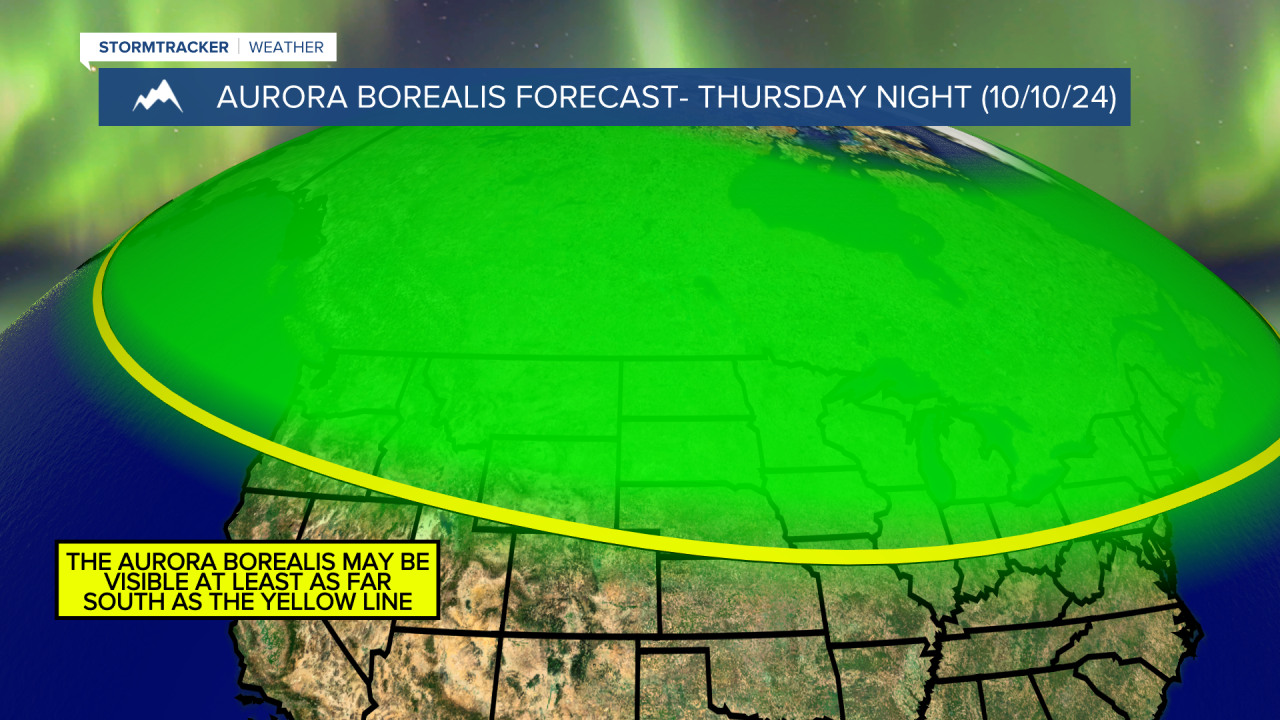
Right now, partly cloudy skies are forecasted for tomorrow night, with decreasing clouds during the first half of the night and increasing clouds during the second half of the night. Based on the current forecast, the aurora borealis may be visible for the entire night, but will be strongest prior to midnight. Also, please note that there is no guarantee that we will see the aurora borealis tomorrow night, but we will continue to keep you updated both on air and online on our chances of seeing it!
On Friday, we are going to have partly cloudy skies with some isolated showers around as another disturbance passes through our area. It is also going to be mild and a little breezy (in some areas) on Friday as highs are going to be in the mid to upper 60s and low 70s and sustained wind speeds are going to be between 5 and 20 mph.
We are then going to have beautiful weather this weekend as we are going to have mainly sunny skies, dry conditions, little wind, and pleasant temperatures as highs are going to be in the 60s on Saturday and the mid to upper 60s and low to mid 70s on Sunday. Definitely make sure you spend some time outdoors this weekend!
Lots of sunshine, mainly dry conditions, and above average temperatures (highs in the 70s) are then expected on Monday, Tuesday, and Wednesday as an upper-level ridge is going to be in control of our weather. It is also going to be a little breezy in some areas on these three days as sustained wind speeds are going to be between 5 and 20 mph.


