

WINTER WEATHER ALERTS are in effect for portions of southwestern and south-central Montana until 12pm Tuesday or 12am Wednesday.

We are going to have partly to mostly cloudy skies tonight with a few scattered snow and rain showers around, especially in the mountains. It is also going to be cool tonight as lows are going to be in the 20s and low 30s, and there is going to be a little breeze around tonight along the Rocky Mountain Front.
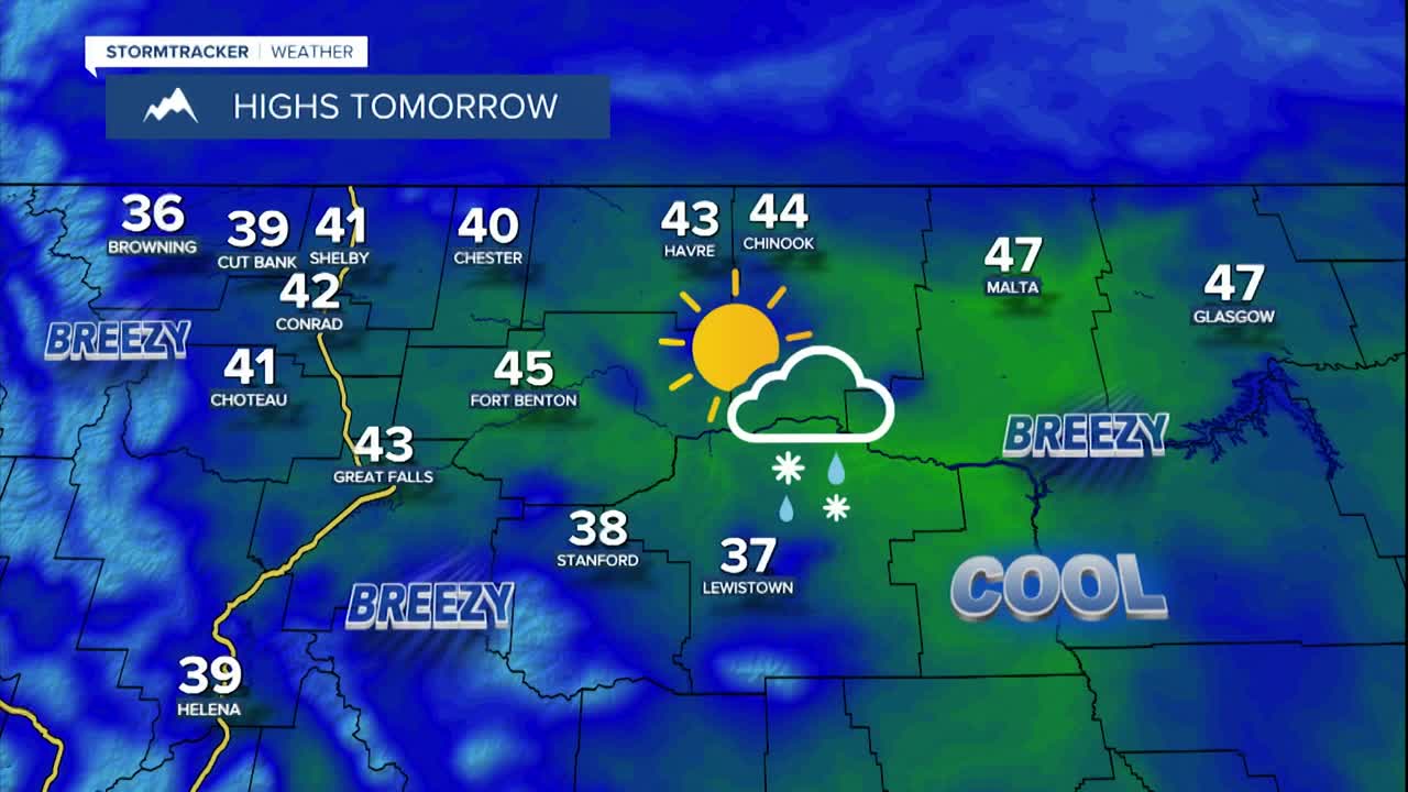
There are then going to be some scattered snow, graupel, and rain showers around tomorrow, generally during the PM hours, as a disturbance passes through our area. These showers will then taper off as we go through tomorrow night. We are also going to have partly cloudy skies tomorrow and decreasing clouds tomorrow night. In the lower elevations, a few isolated areas may receive up to 1” of snow through Wednesday morning, but most locations will receive little to no snow accumulation. In the mountains, a few inches of snow accumulation is possible. This snow will cause some of the mountain passes to be slick at times.
Tomorrow is also going to be the coolest day of the next week as highs are only going to be in the mid to upper 30s and low to mid 40s. There is also going to be a breeze around tomorrow as sustained wind speeds are going to be between 10 and 25 mph.
An upper-level ridge will then provide us with beautiful weather on Wednesday as we are going to have lots of sunshine, dry conditions, and warmer temperatures as highs are going to be in the mid to upper 40s and low to mid 50s. It is also going to be breezy again on Wednesday as sustained wind speeds are going to be between 10 and 25 mph. The Helena Valley will have little wind on Wednesday.
Widespread gusty to strong winds are then expected Thursday, Friday, and this weekend. Across the plains, sustained wind speeds are going to be between 15 and 35 mph, and wind gusts over 50 mph are possible. Along the Rocky Mountain Front, sustained wind speeds are going to be between 20 and 40 mph, and wind gusts over 60 mph are possible. In the Helena Valley, gusty winds are expected on Thursday and Saturday as sustained wind speeds are going to be between 10 and 30 mph, and it will be a bit breezy on Friday and Sunday as sustained wind speeds are going to be between 10 and 20 mph.
On Thursday, there are going to be scattered snow and rain showers around the Helena area, and there are going to be some isolated PM rain and snow showers around in north-central Montana, generally in the mountains, as a disturbance passes through our area. We are also going to have partly to mostly cloudy skies on Thursday. Friday will then be mostly dry with partly to mostly cloudy skies as we are going to be in between disturbances. Rain and snow showers are then likely around Helena on Saturday, and there are going to be some scattered rain and snow showers around in north-central Montana on Saturday, generally during the PM hours, as another disturbance passes through our area. A few more rain and snow showers are then possible on Sunday, generally in the mountains. We are also going to have partly to mostly cloudy skies this weekend.
Seasonable temperatures are also expected from Thursday through Sunday as highs are going to be in the 40s and low to mid 50s in most locations. A big warm-up is then forecasted for next week as highs are going to be in the 50s and 60s, and some locations may hit 70° for the first time this year, especially on Wednesday.


