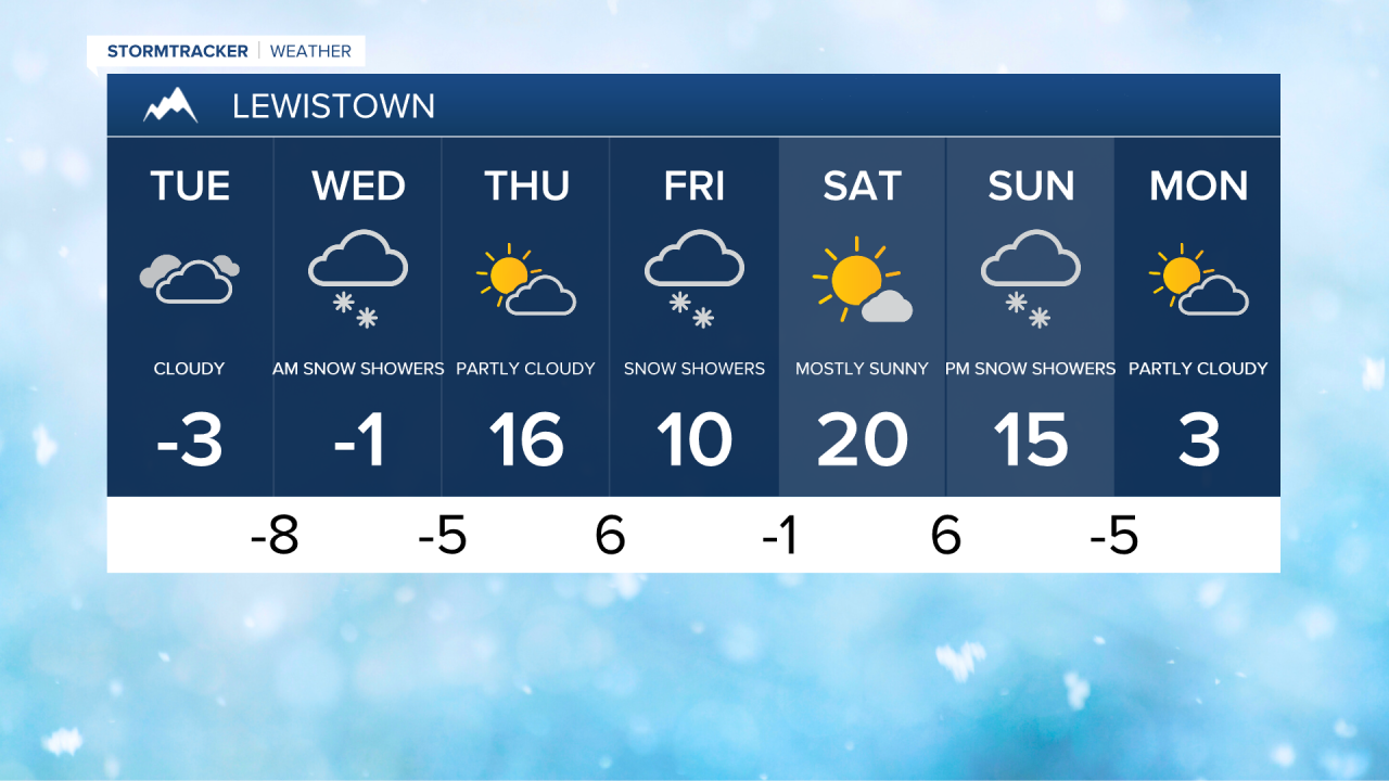
Frigid, wintry weather continues to impact central Montana. An upper-level low centered off of the Washington coast is continuing to direct moisture towards Montana. A band of snow stretching from the mountains in central Idaho all the way to northeastern Montana is going to continue to provide periodic light to moderate snow. This band starts to shift northward this evening, bringing more snow to areas on the Hi-Line.
Snow showers will persist throughout the night into Wednesday morning, followed by a band of moderate to heavy snow as the storm system finally departs our area. The snow will taper off once that moves through, and some areas could even see some sunshine by Wednesday afternoon.
Daytime highs in most areas will only climb to -10° to 0° on Tuesday, and wind chills mostly in the -10s and -20s. Headed into Wednesday, arctic air starts to make a slow retreat to the north. Daytime highs will still only reach -5° to 10° across central and eastern Montana. It will climb into the low to mid 10s in southwest Montana, including for Helena.


In north-central Montana and around the Helena area, most locations will pick up 1-5 inches of additional snow accumulation, with isolated locations receiving up to 7" of new snow. In the mountains along and west of the Divide, 8-12"+ of additional snow is expected. Expect heavy snow at times over Rogers Pass and along Highway 200 between Great Falls and Missoula. Difficult travel conditions will continue due to slick/snow-covered roads and areas of lower visibility through Wednesday afternoon, so please use caution when driving and give yourself plenty of extra time to get to your destination. If you don't already, grab an emergency kit in case you get stuck.
MTN Live Cameras: click here
MDT Road Conditions: click here
MDT Live Cameras: click here
Thursday is going to be a much-needed break from the active weather. We will have partly cloudy skies and slightly warmer temperatures. Daytime highs will be in the 0s, 10s and low to mid 20s, and drier conditions are expected as there are only going to be isolated snow showers around in the mountains.
Another round of light to moderate snow is then expected on Friday as another disturbances passes through the area. Most areas north of Highway 200 will receive little to no snowfall. However, areas to the south could see 1-3 inches of fresh snowfall. It is going to be another frigid day on Friday as highs are going to be in the 0s and 10s.
For this weekend, we can expect partly cloudy skies with a few, scattered snow showers around, especially in the mountains. It won't be as chilly as daytime highs are going to be in the 10s and 20s. The wind will be a bit stronger with speeds between 10 and 20 mph. Another light snowfall is likely Sunday night into Monday, with most areas receiving less than an inch of snowfall.