We're off to another bitterly cold start to your Thursday morning in central Montana, with wind chills well below zero across most of the area. Temperatures are especially cold for the Hi-Line and across southwest Montana, where it is in the -20s and -10s.
![Highs Thursday](https://ewscripps.brightspotcdn.com/dims4/default/9754d8f/2147483647/strip/true/crop/1920x1080+0+0/resize/1280x720!/quality/90/?url=http%3A%2F%2Fewscripps-brightspot.s3.amazonaws.com%2F6d%2F66%2F1aca0c604cabba2484850941716b%2Fkrtv-highs-today-36.png)
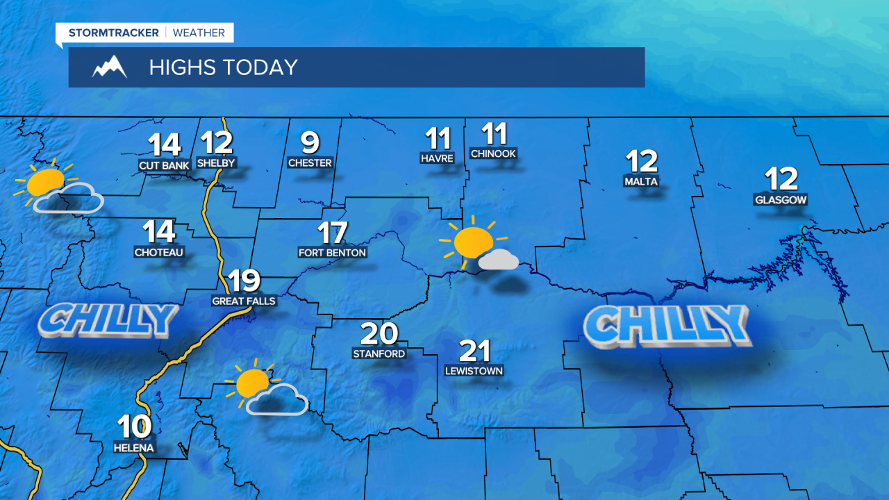
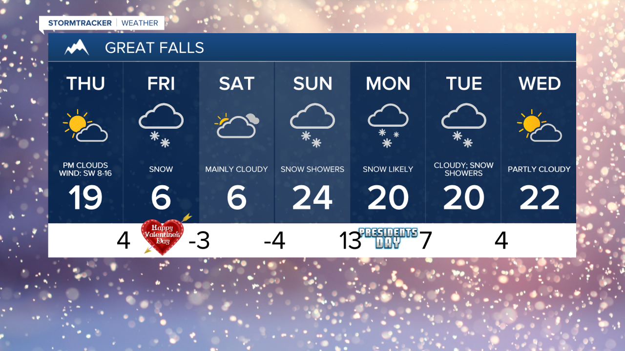
Cloud cover will increase today from southwest to northeast, with a few snow showers developing overnight. A southwest breeze will help to warm temperatures today, with daytime highs in the upper 0s and low to mid 10s for the Hi-Line and mid to upper 10s and lower 20s across central Montana.
![Snowfall forecast](https://ewscripps.brightspotcdn.com/dims4/default/9aabfb6/2147483647/strip/true/crop/1920x1080+0+0/resize/1280x720!/quality/90/?url=http%3A%2F%2Fewscripps-brightspot.s3.amazonaws.com%2F19%2F37%2Fe864a4624e518432aeed40e7c0ae%2Fkrtv-snow-forecast-ryan2-20.png)
A weather system is going to move through later tonight into Friday, bringing on-and-off snow that will continue through Saturday morning. Most areas can expect light snowfall totals, generally around 1-4 inches. However, some areas in the Highwoods and Little Belts could see up to half a foot of snow.
![Snowfall forecast](https://ewscripps.brightspotcdn.com/dims4/default/0c162b7/2147483647/strip/true/crop/1920x1080+0+0/resize/1280x720!/quality/90/?url=http%3A%2F%2Fewscripps-brightspot.s3.amazonaws.com%2F60%2F08%2F3aa2d38f4fa1a267b023fc0d1b4b%2Fkxlh-snow-forecast-ryan-11.png)
A reinforcing surge of arctic air will arrive on Friday and Saturday, keeping highs in the single digits in most locations, although temperatures around Helena will warm up into the teens on Saturday.
A second, stronger weather system will arrive on Sunday, bringing widespread snow from Sunday into Monday. There is the potential for heavier snow along the Montana Highway 87/200 corridor between Great Falls and Lewistown due to upsloping. Snowfall accumulation is likely to be between 3-8 inches. Temperatures will climb into the 10s and 20s on Sunday and Monday.
Confidence is building that the Arctic air parked over Montana will begin to retreat late next week, allowing for a surge of relatively warmer air. Below is the 8-14 day temperature probability outlook, which shows warmer-than-average temperatures across the West. Temperatures could reach 40° by next weekend.
![Climate Prediction Center 8-14 Day Temperature Outlook](https://ewscripps.brightspotcdn.com/dims4/default/cf6becb/2147483647/strip/true/crop/1920x1080+0+0/resize/1280x720!/quality/90/?url=http%3A%2F%2Fewscripps-brightspot.s3.amazonaws.com%2F30%2F23%2Ff5eff7d740e2ade5da5e57abe7eb%2F8-14-day-outlook-new.png)
![Great Falls 7-day](https://ewscripps.brightspotcdn.com/dims4/default/96ffdf9/2147483647/strip/true/crop/1920x1080+0+0/resize/1280x720!/quality/90/?url=http%3A%2F%2Fewscripps-brightspot.s3.amazonaws.com%2F63%2F4d%2F46a74ea64992b91fbbe0a62d0798%2Fgreat-falls-7-day-am-51.png)
![Helena 7-day](https://ewscripps.brightspotcdn.com/dims4/default/584b081/2147483647/strip/true/crop/1920x1080+0+0/resize/1280x720!/quality/90/?url=http%3A%2F%2Fewscripps-brightspot.s3.amazonaws.com%2F7d%2F34%2F7b58a9f0492ca9fd647aded156ee%2Fhelena-7-day-am-44.png)
![Havre 7-day](https://ewscripps.brightspotcdn.com/dims4/default/8e647f5/2147483647/strip/true/crop/1920x1080+0+0/resize/1280x720!/quality/90/?url=http%3A%2F%2Fewscripps-brightspot.s3.amazonaws.com%2F6b%2Ff7%2F12b4cc1a4ad4a8c59021add169eb%2Fhavre-7-day-weekday-am-45.png)
![Lewistown 7-day](https://ewscripps.brightspotcdn.com/dims4/default/0e9f6f0/2147483647/strip/true/crop/1920x1080+0+0/resize/1280x720!/quality/90/?url=http%3A%2F%2Fewscripps-brightspot.s3.amazonaws.com%2Fa9%2F82%2F88c3925b4530925233ee0ae4f945%2Flewistown-7-day-am-38.png)