We track a warm front lifting in from Southwest Montana today.
Warmer weather is forecast for Southwest Montana up to Helena.
Temperatures in these areas still remain well-below average but warmer than we’ve seen in a while.
Central and Northeast Montana top out much cooler in the teens and single digits once again.
Snow remains isolated to the Rocky Mountain Front today.
Moderate to heavy snow showers fall tonight through the Divide before light to moderate snow showers become widespread through Central Montana by tomorrow morning.
A Winter Storm Warning and Winter Weather Advisory are in effect for parts of the Rocky Mountain Front.
These areas are forecasted to see the highest amount of snow accumulation.
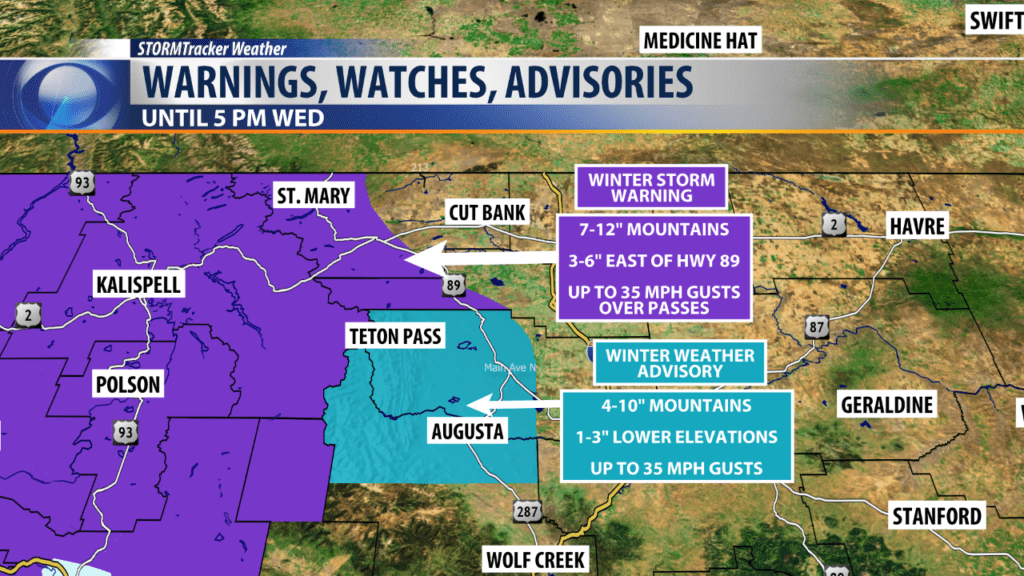
URGENT - WINTER WEATHER MESSAGE
National Weather Service Great Falls MT
409 AM MST Tue Feb 12 2019

MTZ009-122315-
/O.EXT.KTFX.WS.W.0004.000000T0000Z-190214T0000Z/
Northern Rocky Mountain Front-
Including Logan Pass, Marias Pass, Browning, and Heart Butte
409 AM MST Tue Feb 12 2019

...WINTER STORM WARNING NOW IN EFFECT UNTIL 5 PM MST WEDNESDAY...

* WHAT...Heavy snow occurring. Additional snow accumulations
  Tuesday through Wednesday of 4 to 7 inches at lower elevations
  east of U.S. Highway 89; 7 to 12 inches up to 6000 feet in
  elevation, including on Marias Pass; and up to 20 inches above
  6000 feet.

* WHERE...Northern Rocky Mountain Front.

* WHEN...Until 5 PM MST Wednesday.

* ADDITIONAL DETAILS...Travel could be very difficult to
  impossible from East Glacier to Marias Pass, as well as on
  portions of Highway 89. Areas of blowing snow could
  significantly reduce visibility.

PRECAUTIONARY/PREPAREDNESS ACTIONS...

A Winter Storm Warning for snow means severe winter weather
conditions will make travel very hazardous or impossible. If you
must travel, keep an extra flashlight, food and water in your
vehicle in case of an emergency.

The latest road conditions for the state you are calling from can
be obtained by calling 5 1 1.

To see a graphical representation of the degree of stress on
young livestock please visit our webpage and select Local
Programs then Cold Air Advisory for Newborn Livestock.
URGENT - WINTER WEATHER MESSAGE
National Weather Service Great Falls MT
409 AM MST Tue Feb 12 2019

MTZ048-122315-
/O.EXT.KTFX.WW.Y.0010.000000T0000Z-190214T0000Z/
Southern Rocky Mountain Front-
Including Bynum, Choteau, and Augusta
409 AM MST Tue Feb 12 2019

...WINTER WEATHER ADVISORY NOW IN EFFECT UNTIL 5 PM MST
WEDNESDAY...

* WHAT...Snow occurring. Additional snow accumulations Tuesday
  through Wednesday of 3 to 5 inches at lower elevations; mostly 6
  to 10 inches above 6000 feet in elevation; but up to 15 inches
  on the mountain peaks.

* WHERE...Southern Rocky Mountain Front.

* WHEN...Until 5 PM MST Wednesday.

* ADDITIONAL DETAILS...Travel could be very difficult for canyon
  access into the Rocky Mountain Front.

PRECAUTIONARY/PREPAREDNESS ACTIONS...

A Winter Weather Advisory for snow means periods of snow will
cause primarily travel difficulties. Expect snow covered roads
and limited visibilities, and use caution while driving.

The latest road conditions for the state you are calling from can
be obtained by calling 5 1 1.

To see a graphical representation of the degree of stress on
young livestock please visit our webpage and select Local
Programs then Cold Air Advisory for Newborn Livestock.
