We track more snow in the forecast through the rest of the afternoon.
A Winter Weather Advisory remains in effect through North Central and Southwest Montana until this afternoon.
Information from the National Weather Service can be found below:
Cooler weather remains in the forecast tomorrow, but the breeze will pick up tomorrow afternoon.
We track a warmer day Wednesday, but snow returns to the forecast by Wednesday afternoon.
URGENT - WINTER WEATHER MESSAGE
National Weather Service Great Falls MT
314 AM MST Mon Jan 21 2019

MTZ009>013-044>051-211800-
/O.CON.KTFX.WW.Y.0003.000000T0000Z-190121T1800Z/
Northern Rocky Mountain Front-Eastern Glacier-Hill-Cascade-
Chouteau-Toole-Liberty-Eastern Pondera-Blaine-
Southern Rocky Mountain Front-Eastern Teton-Judith Basin-Fergus-
Including Logan Pass, Marias Pass, Browning, Heart Butte,
Cut Bank, Havre, Rocky Boy, Rudyard, Great Falls, Cascade, Belt,
Kings Hill Pass, Fort Benton, Carter, Big Sandy, Shelby,
Sunburst, Chester, Whitlash, Brady, Conrad, Chinook, Harlem,
Hays, Bynum, Choteau, Augusta, Fairfield, Dutton, Raynesford,
Stanford, Hobson, Lewistown, Winifred, Lewistown Divide,
and Grass Range
314 AM MST Mon Jan 21 2019

...WINTER WEATHER ADVISORY REMAINS IN EFFECT UNTIL 11 AM MST THIS
MORNING...

* WHAT...Snow occurring. Additional snow accumulations of up to 2
  inches with new snow accumulation of 2 to 4 inches in the
  mountains.

* WHERE...Portions of central and north central Montana.

* WHEN...Until 11 AM MST this morning.

* ADDITIONAL DETAILS...Plan on slippery road conditions.

PRECAUTIONARY/PREPAREDNESS ACTIONS...

A Winter Weather Advisory for snow means periods of snow will
cause primarily travel difficulties. Expect snow covered roads
and limited visibilities, and use caution while driving.

The latest road conditions for the state you are calling from can
be obtained by calling 5 1 1.
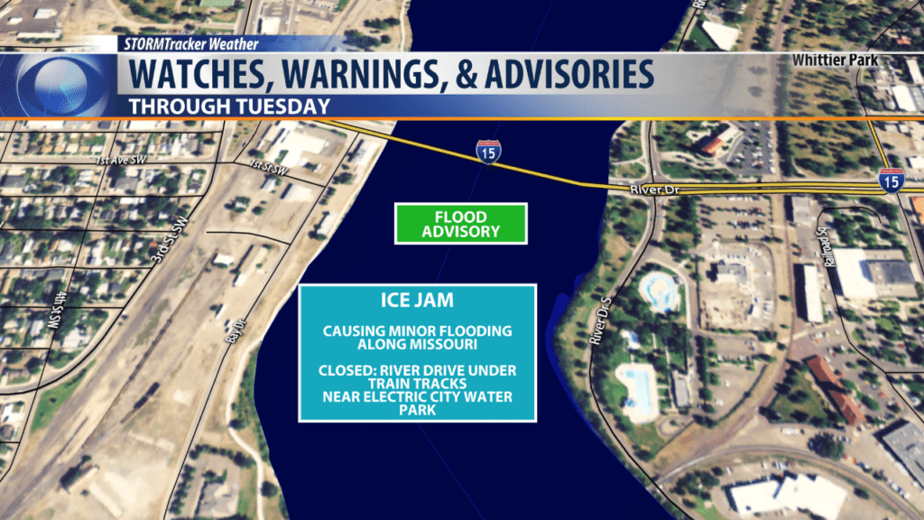
In Great Falls, a Flood Advisory remains in effect through Tuesday.
An ice jam has created minor flooding along River Drive- closing part of the road near the Electric City Water Park near the railroad tracks.
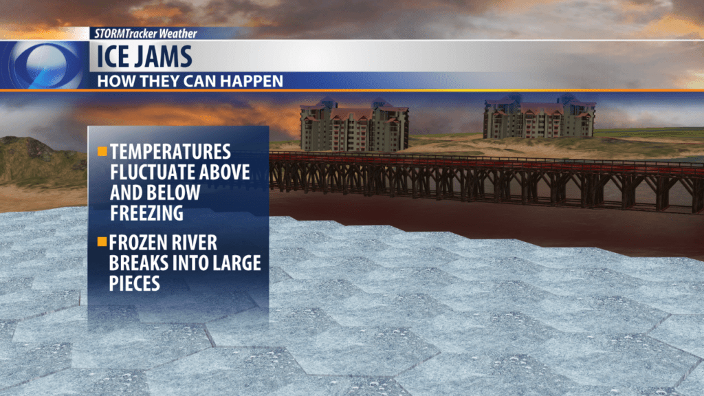
Ice jamming has happened in the area due to fluctuating temperatures from above to below freezing.
This has allowed ice to melt and break apart into large pieces.
Ice then shifted and moved up river and met up with larger parts of ice and jammed- preventing any ice movement.
This ice jam makes water push out and around the ice which causes flooding like the minor flooding seen down by River Drive.

Flood Advisory
National Weather Service Great Falls MT
311 PM MST Sun Jan 20 2019

MTC013-222215-
/O.NEW.KTFX.FA.Y.0002.190120T2211Z-190122T2215Z/
/00000.N.IJ.000000T0000Z.000000T0000Z.000000T0000Z.OO/
Cascade MT-
311 PM MST Sun Jan 20 2019

The National Weather Service in Great Falls has issued a

* Flood Advisory for...
  An Ice Jam in...
  Northern Cascade County in central Montana...

* Until 315 PM MST Tuesday.

* At 309 PM MST, local law enforcement reports that an ice jam
  continues to cause minor flooding in Great Falls, along the
  Missouri River. The flooding has closed River Drive under the
  train tracks near Electric City Water Park.

* Some locations that will experience flooding include...
  Great Falls.

PRECAUTIONARY/PREPAREDNESS ACTIONS...

A Flood Advisory means river or stream flows are elevated, or ponding
of water in urban or other areas is occurring or is imminent.
