


WEATHER DISCUSSION: Themes for the weekend? Dry and hot. While there are very small chances for isolated thunderstorms, hot afternoon temperatures are looking to continue through Monday, with Monday being the hottest day. While the chances for isolated thunderstorms will be low for the rest of Saturday night and Sunday, most of the chances will be on Monday.
The main concern when it comes to the thunderstorms is the wind gusts, that along with low-level humidity and the hot and dry weather elevates fire weather concerns. Currently, there is a Fire Weather Watch in place for Northwestern and Northern Central Montana around the Rocky Mountain Front. The west winds are looking to be around 15 to 25 mph with gusts up to 35 mph, posing a danger especially since the possibility of dry lightning is higher.
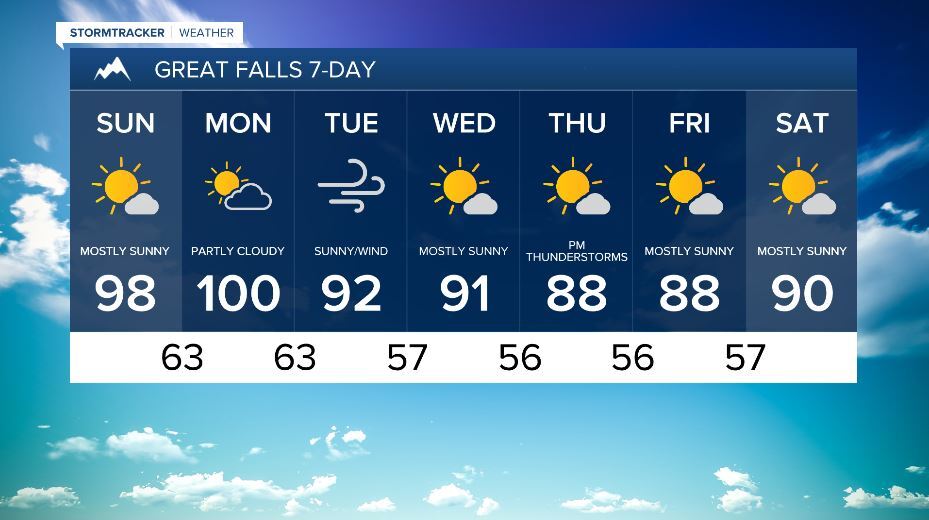
There is also a Heat Advisory in effect for Eastern Montana including the Hi-Line until Monday night. Temperatures have the potential to reach the upper 90’s and hundreds with lows in the 60’s and 70’s, increasing the risk for heat related illnesses. Drink plenty of water and limit outside exposure.
While the weekend had an upper-level ridge lingering over the area, this created the hot and dry conditions with temperatures in the 90’s and 100’s and low chances for thunderstorms. After Monday, the ridge will flatten out into a trough that will begin to cool down temperatures for the rest of the week. Tuesday will see gusty wind conditions and as the week progresses, temperatures will remain around normal for this time of year with daily chances for thunderstorms in the evening and overnight hours.

SATURDAY NIGHT: Areas of smoke. Mostly clear, with a lows in upper 50’s – 60’s. West wind 11 to 16 mph becoming light southwest after midnight. Winds could gust as high as 23 mph.
SUNDAY: Widespread haze before noon. Increasing clouds and hot, with a highs in the upper 90’s and 100’s. The night will see mostly cloudy skies and lows in the 60’s. Light and variable wind becoming east 5 to 8 mph.
MONDAY: Partly sunny and hot then partly cloudy, with a highs near 100’s and lows in the 60’s. Southwest wind 5 to 13 mph with gusts up to 20 mph.
TUESDAY: Sunny with a highs in the 80’s and lows in the 40’s-50’s. West southwest wind 8 to 18 mph, with gusts as high as 29 mph.
WEDNESDAY: Sunny then mostly clear with a highs in the 90’s and lows in the 50’s. Breezy, 5 to 10 mph increasing to 17 to 22 mph in the afternoon with wind gusts as high as 33 mph.
THURSDAY: Sunny then mostly clear with a highs in the 80’s and lows in 50’s.
FRIDAY: Sunny then mostly clear with highs near 90 and lows in the 50’s.
